
Temperatures in april in europe: April Temperature Averages in European Cities
April Temperature Averages in European Cities
Average temperatures for April at major cities throughout Europe are listed below in degrees Celsius and Fahrenheit.
The cities range from Amsterdam to Zurich and from Reykjavík to İstanbul. They are listed alphabetically and you can jump ahead to the section for Amsterdam to Kiev, Leeds to Pristina and Reykjavík to Zurich.
Included in this list are Europe’s national capitals plus cities with a metropolitan population of over one million people.
The tables give the normal maximum and minimum monthly temperatures based on historical weather data collected over a long period, in most cases 30 years.
| High °F | Low °F | City | High °C | Low °C |
|---|---|---|---|---|
| 56 | 40 | Amsterdam, Netherlands | 14 | 5 |
| 61 | 41 | Andorra la Vella, Andorra | 16 | 5 |
| 67 | 53 | Athens, Greece | 19 | 11 |
| 64 | 47 | Barcelona, Spain | 18 | 9 |
| 64 | 47 | Belgrade, Serbia | 18 | 8 |
| 56 | 40 | Berlin, Germany | 13 | 4 |
| 55 | 39 | Birmingham, United Kingdom | 13 | 4 |
| 61 | 41 | Bratislava, Slovakia | 16 | 5 |
| 58 | 42 | Brussels, Belgium | 14 | 5 |
| 64 | 42 | Bucharest, Romania | 18 | 6 |
| 62 | 45 | Budapest, Hungary | 17 | 7 |
| 60 | 42 | Chisinau, Moldova | 16 | 6 |
| 58 | 38 | Cologne, Germany | 14 | 4 |
| 50 | 36 | Copenhagen, Denmark | 10 | 2 |
| 54 | 40 | Dublin, Ireland | 12 | 5 |
| 53 | 39 | Glasgow, United Kingdom | 12 | 4 |
| 54 | 38 | Hamburg, Germany | 12 | 3 |
| 48 | 32 | Helsinki, Finland | 9 | 0 |
| 63 | 48 | İstanbul, Turkey | 17 | 9 |
| 48 | 33 | Kazan, Russia | 9 | 1 |
| 56 | 41 | Kiev, Ukraine | 14 | 5 |
| High °F | Low °F | City | High °C | Low °C |
|---|---|---|---|---|
| 51 | 38 | Leeds, United Kingdom | 11 | 3 |
| 57 | 42 | Lille, France | 14 | 5 |
| 67 | 53 | Lisbon, Portugal | 19 | 12 |
| 60 | 41 | Ljubljana, Slovenia | 15 | 5 |
| 58 | 43 | London, United Kingdom | 15 | 6 |
| 54 | 38 | Luxembourg, Luxembourg | 12 | 3 |
| 61 | 44 | Lyon, France | 16 | 7 |
| 64 | 45 | Madrid, Spain | 18 | 7 |
| 55 | 41 | Manchester, United Kingdom | 13 | 5 |
| 65 | 48 | Marseille, France | 19 | 9 |
| 63 | 45 | Milan, Italy | 17 | 7 |
| 52 | 35 | Minsk, Belarus | 11 | 2 |
| 63 | 50 | Monaco, Monaco | 17 | 10 |
| 51 | 35 | Moscow, Russia | 10 | 2 |
| 55 | 37 | Munich, Germany | 13 | 3 |
| 65 | 47 | Naples, Italy | 18 | 8 |
| 63 | 50 | Nice, France | 17 | 10 |
| 50 | 35 | Nizhny & Novgorod, Russia | 10 | 2 |
| 48 | 33 | Oslo, Norway | 9 | 1 |
| 60 | 45 | Paris, France | 16 | 7 |
| 66 | 48 | Podgorica, Montenegro | 19 | 9 |
| 56 | 36 | Prague, Czech Republic | 13 | 2 |
| 60 | 40 | Pristina, Kosovo | 16 | 4 |
| High °F | Low °F | City | High °C | Low °C |
|---|---|---|---|---|
| 42 | 33 | Reykjavík, Iceland | 6 | 0 |
| 50 | 34 | Riga, Latvia | 10 | 1 |
| 66 | 44 | Rome, Italy | 19 | 7 |
| 61 | 43 | Rostov-on-Don, Russia | 16 | 6 |
| 56 | 40 | Rotterdam, Netherlands | 14 | 4 |
| 47 | 33 | Saint Petersburg, Russia | 8 | 1 |
| 53 | 36 | Samara, Russia | 12 | 2 |
| 62 | 44 | San Marino, San Marino | 17 | 7 |
| 59 | 40 | Sarajevo, Bosnia & Herzegovina | 15 | 4 |
| 65 | 44 | Skopje, Macedonia | 18 | 7 |
| 60 | 40 | Sofia, Bulgaria | 15 | 5 |
| 47 | 34 | Stockholm, Sweden | 9 | 1 |
| 47 | 32 | Tallinn, Estonia | 8 | 0 |
| 66 | 46 | Tirana, Albania | 19 | 8 |
| 62 | 42 | Turin, Italy | 17 | 6 |
| 51 | 31 | Ufa, Russia | 11 | 0 |
| 59 | 41 | Vaduz, Liechtenstein | 15 | 5 |
| 66 | 53 | Valletta, Malta | 19 | 12 |
| 61 | 43 | Vienna, Austria | 16 | 6 |
| 51 | 35 | Vilnius, Lithuania | 11 | 2 |
| 60 | 41 | Volgograd, Russia | 15 | 5 |
| 55 | 37 | Warsaw, Poland | 13 | 3 |
| 61 | 41 | Zagreb, Croatia | 16 | 5 |
| 58 | 37 | Zurich, Switzerland | 15 | 3 |
Top 10 Best Destinations to Visit
Europe in April is at the peak of Spring Season before the scorching summer sun settles in from May and June. April is the most comfortable month for European Holidays as the continent’s weather transforms from the freezing winters to a quite comfortable one during this time.
Also during this time, you get to see so many beautiful flowers blooming in the gorgeous settings of Europe and also enjoy the European Spring fruits and vegetables. This is the last month in Europe to avail of the discounts on airfare and hotels as right after this month, the summer tourist season begins and everything slowly starts getting expensive.
However, it is the incredible scenic beauty, and enjoyable sightseeing tour, a comfortable climate, or a budget-friendly trip. April serves perfection in all aspects, making it an ideal month for Europe vacations.
What is the weather in Europe in April?
April in Northern Europe though it remains cold, unlike the winters, it has plenty of sunshine during this time, so the weather gets comfortable for traveling. The temperature improves from the freezing one and comes around 9 degrees approximately.
In Western Europe, there is more of a spring flavor, and the temperature ranges from 12 to 13 degrees being absolute pleasant and days getting too much longer.
The Eastern side, on the other hand, enjoys complete Spring season in April with a temperature of around 15 degrees and a mixed climate while Middle Europe has quite a warmer weather during this time having a temperature of approximately 20 degrees.
So to help you prepare your holidays, the following list gives you exposure to the best places to travel in Europe in April. And will provide you a respective forecast about the weather in Europe in April.
Table of Contents
- Europe in April: Top 10 Best Destinations to Visit
- Dubrovnik, Croatia
- Ghent, Belgium
- Prague, Czech Republic
- Bologna, Italy
- Barcelona, Spain
- Florence, Italy
- Tallinn, Estonia
- Budapest, Hungary
- Paris, France
- Venice, Italy
- Are you on Pinterest? Pin this for later read!
Europe in April: Top 10 Best Destinations to Visit
Dubrovnik, Croatia
Dubrovnik is a world-famous tourist destination in Croatia located on the Adriatic Sea. It has a pretty comfortable climate during April having temperatures between 14 to 17 degrees. It receives an excellent long 9 to 10 hours of sunshine during April and is among the best places in Europe to visit in April.
The city has impressive architectural works and breathtaking scenic beauty which get a flawless look in the Spring Season in April. The old part of the town is just like a created movie set featuring broad lanes, old marvel houses, narrow winding streets having a cinematic view. April in Dubrovnik is packed with spring festivals and events that help you discover the city from different dimensions.
Festivals like Christian Cultural Day in the first week of April, there are musical events and parties like Club Lazareti in the middle week of April, Easter Brunch Festival, St.Blaise Day, one-week event of Tisuna Molim, Dubrovnik Carnival, Aklapela Vocal Groups Festival and so many to cherish for.
Apart from events, these gorgeous sightseeing attractions like Old City Walls, Stradun of Dubrovnik, City gates, Square of the Loggia, Dubrovnik’s Gibraltar, Recor’s Palace and other numerous beautiful locations will make your vacation worthwhile in the springtime.
Ghent, Belgium
Ghent is a beautiful painted city of Belgium that follows a medieval architecture. You can explore the picturesque town by walking as well as on a boat ride sailing through the city.
While the days have temperatures between 10 to 14 degrees at night, it can drop to 6 degrees even. The weather remains cold with moderate sunshine. The spine thrilling city attractions are amazing to explore in the pleasant spring weather of April like The Count’s Castle, Cathedral of St.Bavo, the breathtaking gothic fortress “Gravensteen,” The belfry, Town Hall, Ruins of Sint –Baafsabdij, Ghent Museum, Museum of Fine Arts, Graslei, and many more.
April also helps you enjoy amazing shopping Sundays in Ghent at various shopping destinations of the city, and you can also check out the Ghent Old market. All museums, historical circles, cultural associations conduct various colorful local events in springtime.
The city has some of the most beautiful street arts, so you can also opt for a graffiti tour and enjoy the nights with musical concerts and nightclubs.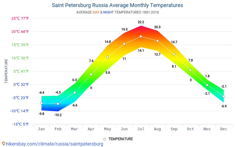
Prague, Czech Republic
Being the capital of the Czech Republic, Prague is crowded with millions of tourists throughout the year due to its packed in attractions. Be it the best places to go in Europe in April or the best European cities to visit in April, Prague ranks in top position in both the categories.
Prague in April bids farewell to the winter season and so the weather mostly remains cold having temperatures between 9 to 14 degrees while at night it may drop to 4 degrees. April is the best time to explore the city attractions, closed parks, and gardens or take a walking city tour.
Various festivals and exhibitions are organized during this time like Exhibition at the Jewish Museum, City Museum, Karel Zeman Museum, etc.
Easter celebrations generally last till April in Prague, and another entertaining event is the ‘Witches Night’ on April 30, which is pretty much like Halloween. It is celebrated to bid goodbye to the freezing winters with bonfire night, creepy colorful costumes, and with hard drinks boozing the entire night.
Other fun events include cruising and jazzing in the jazz boat in the entire April month, the artistic Hieronymous Bosch event, fun Saturdays with shopping and eating at Naplavka riverside market, Spiritual Music concert, and many other big and small events.
Bologna, Italy
Bologna in Italy enjoys a pleasant spring in April having temperatures between 13 to 17 degrees with 6 hours of sunshine. The city has got a significant historical and cultural background that has fallen under the reign of various ruling kingdoms.
April month in Bologna is a hub of exhibitions and cultural events like Dali Experience. The famous portrait of Rittrato d’uomo at Palazzo d’Accursio, Lavoro in Movimento exhibition, San Giacomo Music Festival, Eureka dance show. The musical festival ‘Hair’ celebrating the hippie culture of 1960, the Ocarina Music Festival and the list go on.
Many mesmerizing portraits done by the ancient Italian painter are exposed to the public during this time. The art and music lovers are surely going to love Bologna in April.
Apart from the events, you can also take day and evening tours of the city attractions like Leaning towers, Piazza Maggiore, San Petronio, Archiginassio, Bologna National gallery, Oratory of Battuti and many more. You can spend the nights shopping at la Piazzola Market and dining at the finest city restaurants.
Barcelona, Spain
Spain is one of the hot European countries in April having the peeking of the summer season. Barcelona has the best weather in Europe in April that is neither too hot, nor too cold. The temperatures vary between 13 to 18 degrees with a good amount of sunshine. April is one of the fun times to visit Barcelona due to its entertaining events and comfortable weather.
Festivals like Sant Jordi’s day celebrates the city crowded with roses as on this occasion men gift red roses to their lady love, Feria de Abril which is the April fair organized in the last week of the month.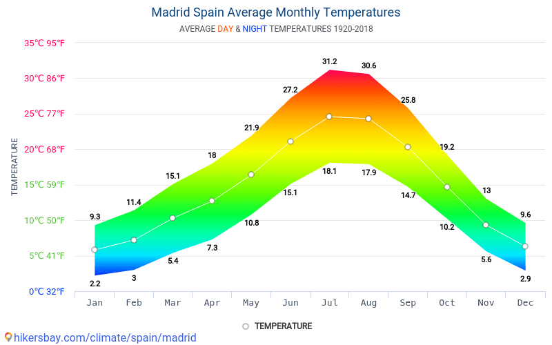
The Cursa de Bombers which is a racing event of the firefighters on April 22. Semana Santa is conducting religious parades, and the Barcelona International Auteur Film Festival and many other activities.
Apart from cherishing the events, you can spend the day with the sightseeing tour and taste the lip-smacking Spanish cuisines. It features in the top 5 list of the best places to travel in Europe in April.
Florence, Italy
Florence is among the most romantic destinations in Italy that are loved by tourists across the world. The old architectures, narrow cobbled streets, exotic wines, opera theatres make the city more charming like a painted old town.
Florence is another city to have the best weather in Europe in April with temperatures between 14 to 19 degrees with 9 hours of sunshine. The climate is excellent to explore its local attractions like Museums, Art galleries, cathedrals, and other gorgeous tourist destinations. A lot of festivals embark the April month in Florence like Easter Celebration at the beginning of April Month.
Festival of Scarperia in the first Sunday of the month, Handicrafts and other vintage display exhibits at Aprilante in the first Sunday of the month, Greve in Chianti in the 4th Sunday of April, last Florence supper on April 5 at the churches, running and cycling festival at Vivicita in the middle week of April, the beautiful spring nursery blooming with flowers in Borgo San Lorenzo, Handicrafts Trade Fair in the last week of April Florence bike festival, and many other events in honor of welcoming the spring season.
You cannot get enough of the evens in Florence in April and the fantastic nights at the classic Opera theatres. So if you are thinking of where to travel in Europe in April, don’t miss Florence at any cost.
Tallinn, Estonia
Tallinn is a beautiful city of Estonia that seems to come straight from the fairyland. The temperature here ranges between 6 to 11 degrees having a cold climate and at night sometimes even drop to 0 degrees.
If you are a scenic beauty admirer, this is the place you should visit in April, to see the colorful conical roofs peeking through the city in daylight accompanied by the blue seas and colorful red trees. The town looks breathtaking drowned in the flavors of Springs.
The city hosts many cultural events during this time like Tallinn Craft beer festival at the beginning of April, Tallinn TV Tower Run in the April 3, Estonian Musical concerts in the middle week of April, Handicraft Fair in the last week of the month, Tallinn International Festival Jazzkaar in the last week of April, Simple Session festival featuring the BMX and snowboarding event, and many more. You can also go to city attractions and cathedrals during the daytime.
Budapest, Hungary
Budapest in Hungary ranks among the best places in Europe to visit in April due to its numerous festivals, concerts, exhibitions, and cultural events for the tourists and residents during this time.
The scenic beauty is also lovely in Budapest during April with blooming flowers beautifying the lush greeneries that make the entire city look bright and gorgeous under the spring sky.
The temperature of Budapest in April is around 11 to 15 degrees offering cold and pleasant weather for sightseeing, city tours and enjoying the festivals.
Be it walking under the Chain Bridge, tasting the exotic Hungarian food and wines, go for cruising at the Danube river, take a dip in the Szechenyi Baths.
Explore the caves of Budapest, spend quality time at the Buda castle or taste the traditional Hungarian food and go for a city touring.
Everything feels worthwhile under the Spring sky of April. The festival events like spring fair, Budapest Spring Festival, Budapest Art week, International Book Festival, Vince Festival, and Exhibitions at museums are going to make your trip extremely fun and entertaining.
Paris, France
Paris is one such beautiful destination of France that looks breathtaking irrespective of season and climate. It is a favorite European destination for all tourists and also a famous honeymoon destination. In April, Paris has a temperature between 11 to 16 degrees with moderate sunshine.
The city looks like a painted picture during spring bordered by the greeneries, beautiful structures, and streets and shining under the blue sky.
April is the month of the photographers to take some million dollar shots of the beautiful city. Various events are conducted during this time like Easter celebrations, Paris marathon, and exhibitions at the Grand Palais, and Paris Art fair. There are colorful and fun events for the kids at Disneyland, funfairs, Trades shows, Music concerts, and lots of cultural events.
Apart from these, you can go to the city attractions like Eiffel Tower, Notre-Dame Cathedral, Musse du Louvre, and many other attractive locations.
Venice, Italy
Venice, which is also known as the paradise of Italy, is excellent to travel in April. The temperatures are quite pleasant, varying between 12 to 16 degrees. April has a lovely beginning in Venice with the Easter celebrations, classical music concerts, and the event of Benedizione del Fuoco organized at Saint marks basilica.
The second and third week houses the events like Festa di San Marco in the last week of April, Venice Jazz festival, Italian Liberation Day celebration on April 25, plenty of opera concerts, and many more cultural events.
Also, this time has lesser city crowds, and hence you can breathe the beautiful city exploring and cruising through the attractive destinations. The city has an enchanting beauty in the springtime blooming with flowers and reflecting brightly with the amazing blue water bodies.
Are you on Pinterest? Pin this for later read!
128
shares
Surface air temperature for April 2022
cross
close
image/svg+xmlEuropean Commission
Copernicus | Europe’s eyes on Earth
IMPLEMENTED BY ECMWF
April 2022 was globally around the sixth warmest April since records began. April temperatures over much of Europe were close to average values for 1991-2020. Temperatures were unusually high from north-eastern Africa across the Middle East to central and southern Asia. Pre-monsoon temperatures were extremely high over Pakistan and northern India.
April 2022
Surface air temperature anomaly for April 2022 relative to the April average for the period 1991-2020. Data source: ERA5. Credit: Copernicus Climate Change Service/ECMWF.
DOWNLOAD THE ORIGINAL IMAGE
DOWNLOAD THE ORIGINAL IMAGE
Surface air temperature anomaly for April 2022 relative to the April average for the period 1981-2010. Data source: ERA5. Credit: Copernicus Climate Change Service/ECMWF.
DOWNLOAD THE ORIGINAL IMAGE
DOWNLOAD THE ORIGINAL IMAGE
Average temperatures for April 2022 differed little from the 1991-2020 April average over northern, western and southern Europe. They were colder than average over central and parts of eastern Europe and warmer than average over the far south-east of the continent.
An extensive region of much-above-average temperatures stretched from north-eastern Africa across the Middle East to central and southern Asia. Pre-monsoon temperatures were exceptionally high over Pakistan and northern India, following record highs in March; the heatwave led to critical water and power shortages as well as damage to crops. Heatwave conditions were also experienced in Egypt and Sudan. High spring temperatures were reported in the Central Asian Republics. Temperatures were also much higher than average over Greenland, easternmost Russia, and the Ross and Weddell sectors of Antarctica. Other regions of above-average temperature include the southern and south-western USA, Mexico, parts of the Far East, and northern Australia.
April 2022 was much colder than average over central and western Canada and much of the ice-covered Arctic Ocean. Temperatures were also below the 1991-2020 average over several other land regions, including north-western Africa, South East Asia, southernmost Africa, south-western Australia and East Antarctica.
Air temperatures were substantially above average over parts of all the major ocean basins. Below-average marine air temperatures were located in the tropical and southern sub-tropical eastern Pacific, indicative of continuing La Niña conditions.
Monthly global-mean and European-mean surface air temperature anomalies relative to 1991-2020, from April 1979 to April 2022. The darker coloured bars denote the April values. Data source: ERA5. Credit: Copernicus Climate Change Service/ECMWF.
ACCESS TO DATA | DOWNLOAD THE ORIGINAL IMAGE
Monthly global-mean and European-mean surface air temperature anomalies relative to 1981-2010, from April 1979 to April 2022. The darker coloured bars denote the April values. Data source: ERA5. Credit: Copernicus Climate Change Service/ECMWF.
ACCESS TO DATA | DOWNLOAD THE ORIGINAL IMAGE
Globally, April 2022 was:
- 0.28°C warmer than the 1991-2020 average for April
- the sixth warmest April on record, though only marginally colder than April 2018
- more than 0.2°C cooler than the warmest Aprils, which were in 2016 and 2020
- marginally warmer than April 2010, the warmest April prior to April 2016.
European-average temperature anomalies are generally larger and more variable than global anomalies. The European-average temperature for April 2022 was 0.42°C lower than the 1991-2020 average. The month was 2.4°C colder than the warmest April, which occurred in 2018, but 0.4°C warmer than April 2021.
The last 12 months – May 2021 to April 2022
Surface air temperature anomaly for May 2021 to April 2022 relative to the average for 1991-2020. Data source: ERA5. Credit: Copernicus Climate Change Service/ECMWF.
DOWNLOAD THE ORIGINAL IMAGE
DOWNLOAD THE ORIGINAL IMAGE
Surface air temperature anomaly for May 2021 to April 2022 relative to the average for 1981-2010. Data source: ERA5. Credit: Copernicus Climate Change Service/ECMWF.
DOWNLOAD THE ORIGINAL IMAGE
DOWNLOAD THE ORIGINAL IMAGE
Temperatures averaged over the last twelve-month period were:
- above average over most land areas and the majority of the ocean surface
- markedly above the 1991-2020 average in a region stretching from northern Arabia to western Siberia, and over northern Siberia, central North America, north-western and central Africa, East Antarctica and the Weddell Sea
- close to average over much of Europe, but above average in the east of the continent, and to a lesser extent over a band eastward from Ireland to southern Scandinavia
- below average over some land areas, including parts of northern Canada and Alaska, north-eastern South America, southern Africa, India, Australia and Antarctica
- below average over the eastern equatorial Pacific, where the La Niña event that peaked in late 2020 reintensified later in 2021 and continued into 2022
- also below average over the Chukchi Sea, parts of the eastern North Pacific and several oceanic areas in the southern hemisphere.


Running twelve-month averages of global-mean and European-mean surface air temperature anomalies relative to 1991-2020, based on monthly values from April 1979 to April 2022. The darker coloured bars are the averages for each of the calendar years from 1979 to 2020. Data source: ERA5. Credit: Copernicus Climate Change Service/ECMWF.
ACCESS TO DATA | DOWNLOAD THE ORIGINAL IMAGE
Running twelve-month averages of global-mean and European-mean surface air temperature anomalies relative to 1981-2010, based on monthly values from April 1979 to April 2022. The darker coloured bars are the averages for each of the calendar years from 1979 to 2020. Data source: ERA5. Credit: Copernicus Climate Change Service/ECMWF.
ACCESS TO DATA | DOWNLOAD THE ORIGINAL IMAGE
There is more variability in average European temperatures, but values are more certain due to the relatively dense observational coverage of the continent. The average for this twelve-month period is 0.41°C above the 1991-2020 average. 2020 is the warmest calendar year on record for Europe by a clear margin, with a temperature 1.2°C above the 1991-2020 average.
Note on global values from ERA5 and other temperature datasets
The spread in global averages from various temperature datasets has been reported previously to have been relatively large over recent years. An updated version of the dataset principally responsible for this spread was released in mid-December 2020. This version agrees much better with other datasets for the latest few years. This version does however show a larger warming since 1850-1900 than its predecessor, which has an influence on the ‘pre-industrial’ estimate as mentioned above. Read more in the Temperature indicator.
There is general agreement among datasets that the period from 2015 to 2020 is much warmer globally than any previous such period. There is also agreement that the global temperature has risen at an average rate close to 0. 2°C per decade since the late 1970s. There is nevertheless still some spread between the datasets for recent years, such as for 2020, and the annual average temperature anomalies for these years from ERA5 are generally higher than those from the five other datasets considered. The differences range from 0.02 to 0.08°C for 2016-2020. The range is 0.00 to 0.07°C if air temperature over sea is replaced by sea-surface temperature for ERA5 and the other dataset for which sea-surface temperature was not used by design. The remaining differences depend partly on the extent to which datasets represent the relatively warm conditions that have predominated over the Arctic and Antarctic during these years. Differences elsewhere in estimates of sea-surface temperature and surface air temperature over land have been further factors.
The average surface air temperature analysis homepage explains more about the production and reliability of the values presented here, but has yet to be updated to include the new information on dataset spread mentioned above.
Back to top
*April Forecast* Weather patterns are now adjusting to the Polar Vortex collapse, creating a weak jet stream as we head deeper into Spring
April weather across the Northern Hemisphere will be shaped by the Polar Vortex collapse event from last month. Unseasonably cold weather events will continue over North America, with a weakened circulation and a disrupted jet stream pattern.
The Polar Vortex is a very powerful short-to-medium term weather driver during every cold season. For this reason, we monitor the activity high above in the stratosphere.
The Polar Vortex underwent a strong collapse event in late March, with the effects now coming down from the higher levels of the atmosphere. The already weak circulation will receive a new wave of disruption.
THE RISE AND FALL OF THE POLAR VORTEX
Every year as we head into autumn, the polar regions receive less and less sunlight. With less solar energy, cooling begins over the north pole.
But as the polar temperatures drop, the atmosphere further south is still relatively warm as it continues to receive light and energy from the Sun.
You can see the winter solstice in the image below. The polar regions receive little to zero solar energy, compared to regions further south, which still continue to receive plenty of sunlight and warmth.
But, as temperature drops over the polar regions, so does the pressure. With colder temperatures over the pole, the temperature difference towards the south increases.
This causes a strong global pressure difference from the poles to the equator, and a large low-pressure (cyclonic) circulation starts to develop across the Northern Hemisphere. It extends from the surface layers, far up into the stratosphere.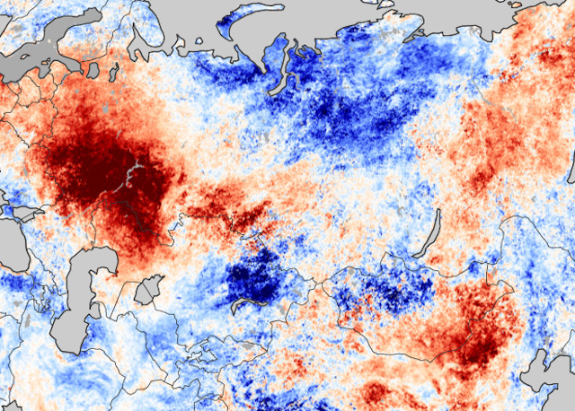 This is known as the Polar Vortex.
You can see the layers of the atmosphere in the image below. The troposphere (blue layer) and the weather are on the bottom and the stratosphere (green layer) with the ozone layer above it.
We produced a 3-dimensional model of the Polar Vortex, extending from the lower levels up into the Stratosphere. The vertical axis is greatly enhanced for better visual purposes. You can see in the image below what the actual structure of the Polar Vortex looks like.
The Polar Vortex behaves like a very large cyclone, covering the whole north pole, down to the mid-latitudes. It is connected through all atmospheric levels, from the ground up, but usually has different shapes at different altitudes.
In the next image below, we have the bottom of the polar vortex at around 5km/3miles. The closer to the ground we go, the more deformed the polar vortex gets because it has to interact with the mountains and overall terrain.
Be aware of its “arms” extending into the lower latitudes, bringing along colder air and snowfall. These arms also pack a lot of energy and can create strong winter storms, like a Noreaster’ in the United States or powerful cyclones in the North Atlantic.
We are typically focusing more on the Stratospheric Polar Vortex, as it plays a very important role in the weather development throughout the season. It is known for its strong influence down from the stratosphere.
A strong Polar Vortex usually means strong polar circulation. This usually locks the colder air into the Polar regions, creating milder conditions for most of the United States and Europe.
In contrast, a weak Polar Vortex can create a weak jet stream pattern. It has a much harder time containing the cold air, which can now escape out of the polar regions, into the United States and/or Europe. Image by NOAA.
Typically, a polar vortex circulation is disrupted due to a rise in temperature and pressure in the stratosphere. That is called a Sudden Stratospheric Warming (SSW) event, which collapses the Polar Vortex.
To put the Polar Vortex into a perspective, we produced a high-resolution video, which shows the recent collapse event of the Polar Vortex.
Video shows the 10mb level (30km/18.5miles) from the GFS model. We can see the Polar Vortex first being split apart, followed by a strong displacement and disintegration.
The main takeaway from the video should be that the Polar Vortex is not just one single winter storm or a cold outbreak that moves from the Midwest into the northeastern United States.
It is a large cyclonic area that is spinning over the entire Northern Hemisphere, from the ground up to the top of the stratosphere, reaching over 50km/31miles in altitude.
POLAR VORTEX COLLAPSE EVENT
We typically use the 10mb level, when analyzing the polar vortex in the stratosphere. That is around 30km (17-20 miles) in altitude.
This layer is considered to be in the mid-stratosphere and is generally a good representation of the strength and status of the stratospheric polar vortex.
The strength of the polar vortex is most often measured by the power of the winds that it produces. This is typically done by measuring the westerly zonal (west to east) wind speeds around the polar circle (60°N latitude).
In the image below we have the seasonal average zonal wind speed for the Polar Vortex at 10mb level. The black line is the long-term average, and the blue line is the analyzed polar vortex strength in the 2021/22cold season.
For the majority of the cold season, the polar vortex was stronger than normal. But in March we can see the rapid collapse of the polar vortex. When the zonal (westerly) winds are reduced below zero in a sharp/rapid event, that is considered a breakdown of the circulation.
But not just winds, the temperature is also of major importance. The colder the polar vortex gets, the stronger it becomes.
Below we have the 2021/2022 season analysis of the stratospheric temperature at 10mb from NASA. The red/pink line is the 21/22 season, which shows the colder than normal polar vortex at the 10mb level in the stratosphere.
But notice the pink line, which shows a rapid temperature from February into March. You can see three distinct warming waves, each stronger than the last one. The final “strongest” peak, was produced in the collapse of the Polar Vortex.
But what exactly was happening up in the higher levels of the atmosphere? And how is it still influencing our weather down here?
Looking at the polar vortex in mid-March below, we can see the vortex was already under pressure from the European and the North Pacific sector. It had an oval shape, and it already began the separation in its core, creating two centers.
Taking a look at the temperature profile at the 10mb level (30km/18.5mi), we can see a warming wave developing over eastern Siberia and a weaker one over northern Canada. Here we can also see the separation of the core into two separate entities.
The collapse process can also be seen in the 3D structure of the polar vortex. The vortex at this point was breaking apart, developing two cores.
The vertical pressure anomaly reveals a connection between the stratosphere and the lower levels. It shows the stratospheric low-pressure areas separated into two cores in mid-March.
Currently, the polar vortex is defeated, and the polar circulation is reversed. The remains of the stratospheric polar vortex are over the eastern north hemisphere, with a high-pressure system taking over.
The 3D structure shows that only the lower level circulation remains. The upper stratospheric part of the polar vortex is gone until the next cold season 2022/23.
The influence of such an event can be seen below. This graphic shows the vertical temperature anomaly. We can see the three warming waves, coming down further from the upper stratosphere.
The final warming event can be tracked now still progressing down, forecast to reach the upper levels of the troposphere.
As you will see now, we can track these stratospheric events in the lower level circulation. That means that it will effectively also influence the weather that we feel.
FROM THE POLAR VORTEX TO THE SURFACE
This first graphic is probably the most important. It shows the vertical pressure anomaly from the surface up into the upper stratosphere. The red square marks the polar vortex collapse event.
We can see by the arrows, that the high-pressure anomaly resulting from the collapse is propagating down. It is connecting to the weather patterns, most strongly in the coming days and into the mid-month.
We can see an anomaly extension around the 10th of April. That coincides with a negative phase of the PNA, seen in the forecast below.
PNA stands for the Pacific North American index, explaining the pressure pattern over North America. A negative phase means lower pressure over western Canada and the western United States.
The weather pattern in the next few days can be seen below and is very disrupted already. High-pressure anomalies are present over the polar circle, with low-pressure systems scattered around. Main low cores are forecast over Scandinavia and the eastern United States.
This pattern is what a weak polar circulation looks like, with a disrupted jet stream. Such weather patterns can generally bring unseasonable (warm/cold) weather to the mid-latitudes.
Such a pattern in the next few days will translate into colder air over northern Europe under the low-pressure system. But the low-pressure system over the eastern United States is bringing down colder weather into the eastern half of the country. Warmer weather remains over the southwestern United States, under the high-pressure.
Taking a closer look at this cold shot over the United States, we can see the colder than normal temperatures spreading over much of the central and eastern United States. Warm weather in the southerly flow prevails over the west coast and western Canada.
The air will be cold enough to bring fresh snowfall into much of the northern United States. This cold outbreak will spread snowfall down from Midwest into the Ohio Valley.
MID-MONTH WEATHER PATTERN
Going into next week, we will be witnessing a shift in the weather pattern. The polar vortex collapse wave will reach further down. We can see stronger high-pressure anomalies building around the polar circle. A strong low-pressure system will descend into western Canada and the western United States.
This is the negative PNA pattern, that was forecast, linked to the overall pressure changes from the Polar Vortex Collapse event.
The temperature forecast for this period shows the cold air following the strong low-pressure system over western Canada and the United States. At the same time, a southerly flow will be established ahead of this low-pressure system, bringing warmer temperatures into the eastern United States and Canada.
Warmer weather will also prevail over western Europe, as colder conditions remain to the east.
Looking closely at this period over the United States, we can see a strong cold air spilling down from Canada into the western United States next week. We can see a strong temperature contrast, with the northerly flow in the west and the southerly warm flow in the northeast.
With such a strong cold air outbreak, more snowfall is expected from the Rockies into the Midwest. The final amount is not yet clear, as the event is too far out, but we can see the early distribution pattern.
NOAA OFFICIAL 8-14 DAY WEATHER OUTLOOK
This is all nicely captured below on the official NOAA/CPC 8-14 day weather forecast. Colder than normal temperatures will prevail over much of the United States, as the low-pressure system crosses the country. Warmer temperatures will move out into the far eastern and southeastern states.
Looking at the official NOAA precipitation forecast, we have a signal for more precipitation over the eastern half of the United States. Less precipitation is expected under the drier cooler northerly flow in the west-central United States, and in the southwest.
WEATHER PATTERNS EVOLVE INTO LATE MONTH
Looking into the second half of the month, the high pressure will remain around the polar circle. Two main low-pressure areas will be again over the eastern United States and northeastern Pacific. The low pressure over the eastern United States is actually the same system that will be moving in from the west next week.
At the same time, a ridge builds again over the western United States, while one remains over western Europe.
In the temperature anomalies for this period, we can see the colder air following behind the low-pressure system in the eastern United States. At the same time, a warmer airmass spreads into the western United States, with the developing ridge.
Looking closer at the United States pattern, we have an example forecast below, showing a possible scenario. The idea is that the low-pressure system next week will move further towards the east, bringing down more cold into the eastern half of the country.
At the same time, a building high-pressure ridge will expand a warmer air mass in the western half.
The precipitation anomaly forecast below shows that the cold air is mostly dry. The main precipitation area is pushed towards the southeastern and eastern parts of the United States.
We do have to repeat, that this is further out in the forecast period, so it serves as an example of a possible scenario. The ensemble forecast supports the disrupted circulation, which is supportive of further cold air intrusions into the United States.
Further down we will also cover the weather trends for late April and early May, and after that, we will look at the seasonal weather into early Summer.
LATE APRIL – EARLY MAY WEATHER PATTERN
The latest extended-range forecast from ECMWF was released this Monday, so we can look at some late April and early May trends.
The pressure pattern forecast for late April shows higher pressure over the lower latitudes. A broad low-pressure zone remains over Siberia and a weaker one is signaled over Canada.
Looking at the temperature forecast for Europe in the same period, we can see mostly warmer than normal temperatures. Colder than normal air is likely to remain mostly over Scandinavia.
The temperature forecast for North America shows the colder temperatures remaining mostly in Canada. An extension is likely into the northern United States. The rest of the country is expected to be warmer than normal under the high-pressure zone.
Going into early May, the high-pressure zones remain. But we have a better signal for low-pressure areas over Canada and northwestern Europe.
Temperatures for this period over Europe are more neutral/normal. It can also be a hint for a likely cold air spill into central Europe around this period.
Over North America, we can see the colder anomalies over Canada. But we can also see a larger neutral extension into the Midwest and towards the central United States. This is likely another cold outbreak event in development, triggered by the low-pressure zone over Canada.
NOAA/NCEP also releases regular weekly forecasts, produced by their CFS model. Below is the temperature anomaly forecast for the same period as the ECMWF extended range above.
The late April forecast on the left also shows the colder air over northern parts of the United States. And going into early May, we have the same hints of a new colder air outbreak down into the Midwest and the eastern United States.
We will now quickly look at the latest seasonal forecast below, extending our look at the weather trends in the coming months.
SPRING TO SUMMER WEATHER OUTLOOK
We typically use the ECMWF long-range model (SEAS-5), as it is often referred to as “the best” solution for long-range forecasting.
The forecast period we will be focusing on is May-June-July (MJJ 2022). This period covers the remaining month of meteorological spring and the first two months of meteorological summer.
In the pressure pattern forecast from ECMWF below, we can see a La Nina high-pressure system remaining in the North Pacific. It extends into the western United States.
A similar high-pressure pair is found over the northeastern United States and over western Europe. A low-pressure area is hinted over northern Europe.
The global temperature distribution of course follows this pattern. Over North America, we see warm pooling over the western United States. That is the warmer airmass under the high-pressure anomaly.
Europe features mostly warmer than normal conditions over the south-central and western parts. Northern Europe however is seen neutral, under a likely low-pressure area.
Looking closer at Europe, we see warm anomalies over most of the continent. But the exception is northern Europe, which will be under the influence of a low-pressure system.
Over North America, we can now better see the warm pooling over much central and western United States. The southeastern United States however does feature a neutral area, hinting at a possible partial northerly flow on the eastern side of a ridge.
Warm anomalies are also forecast over much of central and eastern Canada, and also the northeastern United States. That region is under the influence of the high-pressure system in the region.
The precipitation forecast shows drier conditions over most of the central and northwestern United States. But parts of the southeastern and southwestern United States, and eastern Canada have a higher chance of wetter conditions.
Normal to wetter conditions will prevail over northern Europe under the low-pressure zone. But the rest of the continent is expected to be drier than normal, under the high-pressure anomaly.
This forecast raises concerns about severe drought conditions in much of the western United States. The drought conditions are already present strongly over the west and south, as seen in the analysis below by the United States national drought monitor service.
Looking at the NOAA official temperature outlook, most of the United States is warmer than normal. The core warm anomalies are so far focused on the southern and southwestern United States.
The official precipitation forecast is quite similar to the model forecast. We see an equal-to-higher probability for more precipitation over the northeast. But most of the western United States, however, is forecast to have a drier than normal season from late spring and into summer.
We will release regular weekly and monthly updates on weather development, so make sure to bookmark our page, and also, if you have seen this article in the Google App (Discover) feed, click the like button (♥) there to see more of our forecasts and latest articles on weather and nature in general.
SEE ALSO:
The Gulf Stream continues to slow down, new data shows, with freshwater creating an imbalance in the current, pushing it closer to a Collapse point
Best Time for Northern Europe Cruises (Climate Chart and Table)
On this page, you will find information about the climate and the best time to visit Northern Europe Cruises. We created climate tables and charts for the locations of Bergen, Kirkenes, Reykjavik, Kiel und Copenhagen. These contain details about temperatures, precipitation and more.
Furthermore, we analyzed all climate data and provide a recommendation about which months are best to visit Northern Europe Cruises for your holiday.
Climate Overview
-13 °C to 22 °C
2 °C to 16 °C
0.94 – 11.14 in (3 – 22 Days of Rain)
Average Annual Temperature is between 0 °C (Kirkenes) and 9 °C (Kiel)
Show temperatures in degree
Beach Vacation in March
Diani Beach
29 °C 33 °C
2.2 in
Best Time to Visit Northern Europe Cruises: Overview
|
JanuaryJan MaximumMax. 5 °C |
FebruaryFeb MaximumMax. 5 °C |
MarchMar MaximumMax. 8 °C |
AprilApr MaximumMax. 12 °C |
MayMay Best time to traveltime PerfectPerf. climate in |
JuneJun Best time to traveltime PerfectPerf. climate in |
|
JulyJul Best time to traveltime PerfectPerf. climate in |
AugustAug Best time to traveltime PerfectPerf. climate in |
SeptemberSep Good time to traveltime PerfectPerf. climate in |
OctoberOct MaximumMax. 13 °C |
NovemberNov MaximumMax. 7 °C |
DecemberDec MaximumMax. 5 °C |
 6 °C
6 °C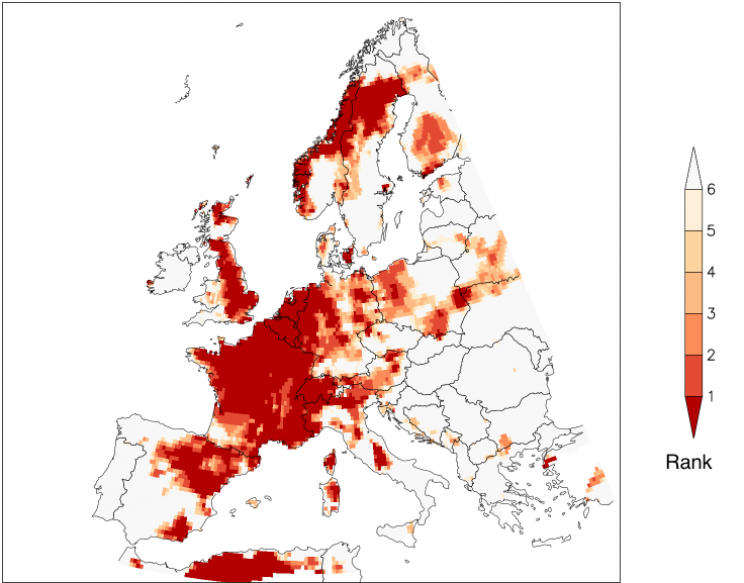 8 °C
8 °CBest Time to Visit the Regions
Find the best time to visit the regions (Northern Europe Cruises) in the following overview.
| Location | Best Time to Travel |
|---|---|
| Bergen | May, June, July, and August |
| Kirkenes | May, June, July, August, and September |
| Reykjavik | May, June, July, August, and September |
| Kiel | May, June, July, August, and September |
| Copenhagen | May, June, July, August, and September |
Climate Charts Northern Europe Cruises
In the following, you will find climate charts for the regions.
Furthermore, there are some charts you can use for quick comparison of climate between the regions.
Show Climate Chart for BergenKirkenesReykjavikKielCopenhagenComparison Day TemperaturesComparison Night TemperaturesComparison Average TemperaturesComparison Water TemperaturesComparison PrecipitationComparison Hours of SunshineShow all
Bergen
Show temperatures in degree
Kirkenes
Show temperatures in degree
Reykjavik
Show temperatures in degree
Kiel
Show temperatures in degree
Copenhagen
Show temperatures in degree
Day Temperatures
Show temperatures in degree
Night Temperatures
Show temperatures in degree
Average Temperatures
Show temperatures in degree
Water Temperatures
Show temperatures in degree
Precipitation
Hours of Sunshine per Day
Source of Data: German Weather Service (Offenbach) and Wikipedia
Climate Tables Northern Europe Cruises
In the following, you will find some climate tables for Northern Europe Cruises, containing information about Temperatures, Precipitation, Water Temperatures, and Hours of Sunshine.
Show climate table for BergenKirkenesReykjavikKielCopenhagenAll
Temperatures, Precipitation, Sunshine in Bergen (Northern Europe Cruises)
| Jan | Feb | Mar | Apr | May | Jun | Jul | Aug | Sep | Oct | Nov | Dec | |
|---|---|---|---|---|---|---|---|---|---|---|---|---|
| Day Temperature | 3° | 3° | 5° | 8° | 13° | 16° | 17° | 17° | 14° | 10° | 6° | 4° |
| Night Temperature | -1° | -1° | 0° | 2° | 6° | 9° | 10° | 11° | 9° | 6° | 2° | -0° |
| Precipitation (inch) | 7.48 | 5.98 | 6.69 | 4. 49 49 |
4.17 | 5.2 | 5.83 | 7.48 | 11.14 | 10.67 | 10.2 | 9.25 |
| Rainy days | 20 | 15 | 17 | 13 | 14 | 11 | 15 | 17 | 20 | 22 | 17 | 21 |
| Hours of Sunshine | 1 | 2 | 3 | 5 | 6 | 6 | 5 | 5 | 3 | 2 | 1 | 0 |
Show temperatures in degree
Temperatures
The annual average temperature in Bergen is 6.9 °C.
For comparison: London 11 °C, NYC 12 °C, LA 17.9 °C
Warmest month: August (13. 8 °C)
8 °C)
Coldest month: February (0.8 °C)
Precipitation
Overall annual precipitation: 88.58 inch on 202 rainy days
For comparison: London 24.06 in, NYC 41.57 in, LA 12.01 in
Rainy season (months with more than 6.9 in of precipitation): January, August, September, October, November, and December
Overall precipitation in the rainy season: 56.22 in
Months that have possible snowfall: January, February, March, April, November, and December
Sunshine
As our climate table shows, June is the sunniest month with an average of 6.3 hours of sunshine per day. Over the year, there are 3.2 hours of sunshine per day on average. For comparison: London has 4.1, NYC has 7 and LA has 8.9 hours of sunshine per day on average.
Temperatures, Precipitation in Kirkenes (Northern Europe Cruises)
| Jan | Feb | Mar | Apr | May | Jun | Jul | Aug | Sep | Oct | Nov | Dec | |
|---|---|---|---|---|---|---|---|---|---|---|---|---|
| Day Temperature | -6° | -6° | -4° | 1° | 6° | 12° | 15° | 13° | 9° | 2° | -3° | -4° |
| Night Temperature | -13° | -12° | -9° | -5° | -1° | 5° | 8° | 8° | 4° | -1° | -6° | -11° |
| Precipitation (inch) | 1. 3 3 |
1.22 | 1.02 | 1.1 | 0.94 | 2.01 | 2.44 | 2.28 | 1.61 | 1.85 | 1.42 | 1.38 |
| Rainy days | 4 | 3 | 3 | 4 | 8 | 12 | 13 | 13 | 13 | 11 | 6 | 5 |
Show temperatures in degree
Temperatures
The annual average temperature in Kirkenes is 0 °C.
Warmest month: July (11.6 °C)
Coldest month: January (-9.7 °C)
Precipitation
Overall annual precipitation: 18.58 inch on 95 rainy days
There is no rainy season (months with more than 6.9 in of precipitation).
Months that have possible snowfall: all except June, July, and August
Temperatures, Precipitation, Sunshine in Reykjavik (Northern Europe Cruises)
| Jan | Feb | Mar | Apr | May | Jun | Jul | Aug | Sep | Oct | Nov | Dec | |
|---|---|---|---|---|---|---|---|---|---|---|---|---|
| Day Temperature | 2° | 3° | 3° | 6° | 9° | 12° | 13° | 13° | 10° | 7° | 3° | 2° |
| Night Temperature | -3° | -2° | -2° | 0° | 4° | 7° | 8° | 8° | 5° | 2° | -1° | -3° |
| Water Temperature | 6° | 6° | 6° | 7° | 8° | 9° | 11° | 11° | 10° | 8° | 8° | 7° |
| Precipitation (inch) | 3. 5 5 |
2.52 | 2.44 | 2.2 | 1.65 | 1.65 | 1.97 | 2.2 | 2.64 | 3.7 | 3.07 | 3.11 |
| Rainy days | 13 | 13 | 14 | 12 | 10 | 11 | 10 | 12 | 12 | 15 | 13 | 14 |
| Hours of Sunshine | 1 | 2 | 4 | 5 | 6 | 5 | 6 | 5 | 4 | 3 | 1 | 0 |
Show temperatures in degree
Temperatures
The annual average temperature in Reykjavik is 4.4 °C.
Warmest month: July (10. 8 °C)
8 °C)
Coldest month: January (-0.6 °C)
The maximum water temperature in Reykjavik is 11 °C. You cannot take a bath with these temperatures.
Precipitation
Overall annual precipitation: 30.67 inch on 149 rainy days
There is no rainy season (months with more than 6.9 in of precipitation).
Months that have possible snowfall: all except June, July, and August
Sunshine
As our climate table shows, May is the sunniest month with an average of 6.2 hours of sunshine per day. Over the year, there are 3.5 hours of sunshine per day on average.
Temperatures, Precipitation, Sunshine in Kiel (Northern Europe Cruises)
| Jan | Feb | Mar | Apr | May | Jun | Jul | Aug | Sep | Oct | Nov | Dec | |
|---|---|---|---|---|---|---|---|---|---|---|---|---|
| Day Temperature | 5° | 5° | 8° | 12° | 16° | 19° | 21° | 21° | 17° | 13° | 7° | 5° |
| Night Temperature | 0° | 0° | 2° | 4° | 7° | 10° | 13° | 13° | 10° | 7° | 3° | 0° |
| Precipitation (inch) | 2. 83 83 |
1.98 | 2.43 | 1.67 | 1.79 | 2.78 | 3.46 | 2.82 | 2.92 | 2.86 | 2.24 | 3.02 |
| Rainy days | 12 | 12 | 12 | 9 | 8 | 12 | 11 | 10 | 11 | 11 | 11 | 12 |
| Hours of Sunshine | 1 | 2 | 3 | 6 | 7 | 8 | 7 | 7 | 5 | 3 | 2 | 1 |
Show temperatures in degree
Temperatures
The annual average temperature in Kiel is 9 °C.
Warmest month: July (17. 1 °C)
1 °C)
Coldest month: January (2.3 °C)
Precipitation
Overall annual precipitation: 30.79 inch on 131 rainy days
There is no rainy season (months with more than 6.9 in of precipitation).
Months that have possible snowfall: January, February, March, April, November, and December
Sunshine
As our climate table shows, June is the sunniest month with an average of 7.6 hours of sunshine per day. Over the year, there are 4.4 hours of sunshine per day on average.
Temperatures, Precipitation, Sunshine in Copenhagen (Northern Europe Cruises)
| Jan | Feb | Mar | Apr | May | Jun | Jul | Aug | Sep | Oct | Nov | Dec | |
|---|---|---|---|---|---|---|---|---|---|---|---|---|
| Day Temperature | 2° | 2° | 5° | 11° | 16° | 20° | 22° | 21° | 18° | 12° | 7° | 4° |
| Night Temperature | -2° | -3° | -1° | 3° | 8° | 11° | 14° | 14° | 11° | 7° | 3° | 1° |
| Water Temperature | 3° | 2° | 3° | 5° | 9° | 14° | 16° | 16° | 14° | 12° | 8° | 5° |
| Precipitation (inch) | 2. 01 01 |
1.22 | 1.65 | 1.65 | 1.69 | 2.13 | 2.72 | 2.48 | 2.44 | 2.32 | 2.44 | 2.28 |
| Rainy days | 11 | 7 | 10 | 8 | 8 | 9 | 9 | 9 | 10 | 10 | 13 | 10 |
| Hours of Sunshine | 1 | 2 | 4 | 6 | 9 | 9 | 8 | 7 | 6 | 3 | 2 | 1 |
Show temperatures in degree
Temperatures
The annual average temperature in Copenhagen is 8.5 °C.
Warmest month: July (17. 7 °C)
7 °C)
Coldest month: February (-0.2 °C)
The maximum water temperature in Copenhagen is 16 °C. Bathing would be very uncomfortable.
Precipitation
Overall annual precipitation: 25.04 inch on 114 rainy days
There is no rainy season (months with more than 6.9 in of precipitation).
Months that have possible snowfall: January, February, March, April, November, and December
Sunshine
As our climate table shows, June is the sunniest month with an average of 8.8 hours of sunshine per day. Over the year, there are 4.7 hours of sunshine per day on average.
Popular Activities
More attractions
From Reykjavik: Jökulsárlón Glacier Lagoon Full-Day Trip | Iceland: Northern Lights Bus Tour from Reykjavik | From Reykjavik: Golden Circle Full Day Tour | Keflavik Airport (KEF): Transfer to/from Reykjavik | Copenhagen: 1-Hour Canal Cruise from Ved Stranden or Nyhavn | Keflavík Airport (KEF): Bus Transfer to/from Reykjavik | From Reykjavik: Whale Watching Tour |
Current Weather and Forecast
Current Weather in Bergen
broken clouds, 9. 3 °C
3 °C
Clouds: 75 % Wind: 16 mph SSO
Air Pressure: 1017 hPa Humidity: 53 %
Last updated: 12th Mar 2022, 11:40 pm
The next days …
| 6th Mar 2022 | 7th Mar 2022 | 8th Mar 2022 | 9th Mar 2022 | 10th Mar 2022 | 11th Mar 2022 |
|---|---|---|---|---|---|
| -1 °C to 4 °C | 0 °C to 5 °C | 0 °C to 6 °C | 1 °C to 8 °C | 4 °C to 6 °C | 4 °C to 8 °C |
| -1 °C to 4 °C | 0 °C to 5 °C | 0 °C to 6 °C | 1 °C to 8 °C | 4 °C to 6 °C | 4 °C to 8 °C |
| Clouds: 7 % | Clouds: 100 % | Clouds: 43 % | Clouds: 35 % | Clouds: 100 % | Clouds: 76 % |
| No Precipitation | No Precipitation | No Precipitation | No Precipitation | 0.48 in of rain | 0.05 in of rain |
Weather information provided by OpenWeatherMap. (CC BY-SA)
Show temperatures in degree
Cruises: Regions
Northern Europe Cruises is part of the holiday destination Cruises. We analyzed the climate for additional regions, in order to provide you with information about the best time to visit and the expected holiday weather:
Cruises | Mediterranean Cruises | Caribbean Cruises | Canary Islands Cruises | Middle East Cruises | Asia Cruises | Baltic Sea Cruises | Alaska Cruises | South America Cruises | South Pacific Cruises | Northern America Cruises | Nile River Cruises | Danube River Cruises | Rhine River Cruises | Hawaii Cruises |
Hottest Month
July: 22 °C
Day Temperature in Copenhagen
Coldest Month
January: -13 °C
Night Temperature in Kirkenes
Rainiest Month
September: 11.14 in
Rain in Bergen
Driest Month
May: 0.94 in
Rain in Kirkenes
Maximum Water Temperature
July: 16 °C
Water Temperature in Copenhagen
Sunniest Month
June: 8. 8 hours/day
Sunshine in Copenhagen
Activities and Attractions
Distances to Northern Europe Cruises
| London | New York | Los Angeles | |
|---|---|---|---|
| Bergen | 650 mi | 3490 mi | 5180 mi |
| Kirkenes | 1590 mi | 3920 mi | 5090 mi |
| Reykjavik | 1170 mi | 2620 mi | 4310 mi |
| Kiel | 470 mi | 3800 mi | 5610 mi |
| Copenhagen | 590 mi | 3840 mi | 5600 mi |
Show Bergen on Map
Show Kirkenes on Map
Show Reykjavik on Map
Show Kiel on Map
Show Copenhagen on Map
Continent: Europe
All Holiday Destinations in Europe
Proof of Image Sources
Share your Experience and Win
We want to know: how was the weather during your Northern Europe Cruises holiday? You can win a travel coupon of 1000 $. The price will be raffled among all submissions.
JanuaryFebruaryMarchAprilMayJuneJulyAugustSeptemberOctoberNovemberDecember When was your Northern Europe Cruises holiday?
5 (Excellent)4 (Good)3 (Mixed)2 (Tricky)1 (Mostly bad)0 (Catastrophic) Please rate the weather with 0 to 5 stars.
Describe the travel weather during your holiday in your own words!
First Name
years old
E-Mail (voluntary disclosure, will not be shared)
All information entered will be stored according to our privacy policy.
Arctic Ocean: Powered by Nature
Destinations in the Vicinity …
The Best Time to Visit Eastern Europe for Weather, Safety, & Tourism
The best times to visit Eastern Europe for ideal weather are
May 28th to August 19th
based on average temperature and humidity from NOAA (the National Oceanic and Atmospheric Administration). Read below for more weather and travel details.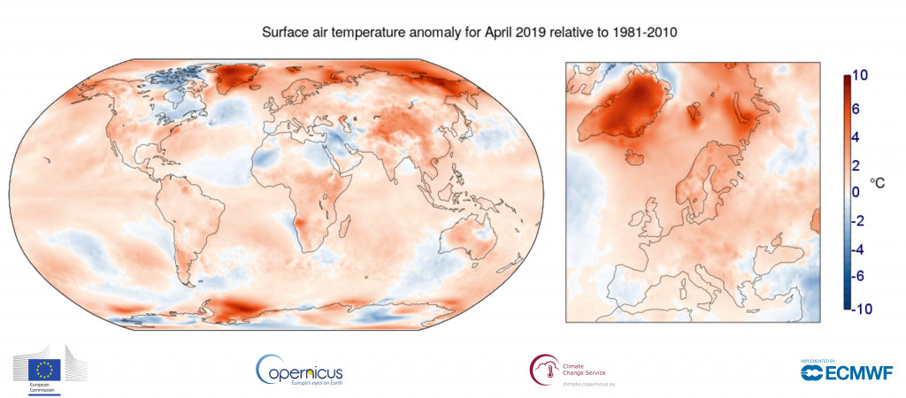
Eastern Europe Travel Guide
- Weather
- Temperature
- Perceived Temperature
- Rain and snow
- Humidity and wind
Other Eastern Europe Travel Info
Weather in Eastern Europe
Temperature
Average temperatures in Eastern Europe vary an incredible amount. Considering humidity, temperatures feel cold for most of the year with a low chance of precipitation most of the year. The area is less temperate than some — in the 33rd percentile for pleasant weather — compared to tourist destinations worldwide. Weeks with ideal weather are listed above. If you’re looking for the very warmest time to visit Eastern Europe, the hottest months are July, June, and then August. See average monthly temperatures below. The warmest time of year is generally mid July where highs are regularly around 77. 4°F (25.2°C) with temperatures rarely dropping below 54.6°F (12.6°C) at night.
Eastern Europe Temperatures (Fahrenheit)
Key
High
Average
Low
Eastern Europe Temperatures (Celsius)
Key
High
Average
Low
“Feels-Like” Temperatures
The way we experience weather isn’t all about temperature. Higher temperatures affect us much more at higher humidity, and colder temperatures feel piercing with high winds. Our perceived temperatures factor in humidity and wind chill to better represent how hot or cold the day feels to a person.
Eastern Europe Perceived Temperature (F)
Key
High
Average
Low
Eastern Europe Perceived Temperature (C)
Key
High
Average
Low
Average Eastern Europe Temperatures by Month
Daily highs (averaged for the month) usually give the best indication of the weather. A significantly lower mean and low generally just means it gets colder at night.
Show Fahrenheit
| Month | Avg. High (°F) | Avg. Mean (°F) | Avg. Low (°F) |
|---|---|---|---|
| Jan | -0.4 | -7.3 | -16.3 |
| Feb | 7.5 | 0.2 | -9.5 |
| Mar | 23.1 | 15.7 | 4.1 |
| Apr | 41.1 | 33.8 | 24.2 |
| May | 53.7 | 45.4 | 34.6 |
| Jun | 70.8 | 62.3 | 50.4 |
| Jul | 73.7 | 65 | 53.6 |
| Aug | 66.2 | 57.7 | 47.3 |
| Sep | 52.2 | 45.4 | 37.4 |
| Oct | 32.8 | 28.1 | 21.5 |
| Nov | 16.9 | 10.9 | 2.2 |
| Dec | 10 | 4.2 | -4.1 |
Show Celsius
| Month | Avg. High (°C) | Avg. Mean (°C) Mean (°C) |
Avg. Low (°C) |
|---|---|---|---|
| Jan | -18 | -21.8 | -26.8 |
| Feb | -13.6 | -17.7 | -23.1 |
| Mar | -4.9 | -9.1 | -15.5 |
| Apr | 5.1 | 1 | -4.3 |
| May | 12.1 | 7.4 | 1.4 |
| Jun | 21.6 | 16.8 | 10.2 |
| Jul | 23.2 | 18.3 | 12 |
| Aug | 19 | 14.3 | 8.5 |
| Sep | 11.2 | 7.4 | 3 |
| Oct | 0.4 | -2.2 | -5.8 |
| Nov | -8.4 | -11.7 | -16.6 |
| Dec | -12.2 | -15.4 | -20.1 |
Precipitation (Rain or Snow)
If dry weather is what you’re after, the months with the lowest chance of significant precipitation in Eastern Europe are January, December, and then February. Note that we define “significant precipitation” as .1 inches or more in this section. The lowest chance of rain or snow occurs around early January. For example, on the week of January 1st there are no days of precipitation on average. By contrast, it’s most likely to rain or snow in early June with an average of 3 days of significant precipitation the week of June 4th.
When can you find snow in Eastern Europe? Weather stations report far greater snow than most tourist destinations snow through most of the year likely to be deepest around March, especially close to mid March. The best time to ski (if at all) in Eastern Europe is often around around March 12th when fresh powder is deepest. Please note that a value of 0 for snow in the graph below may either mean there was no snow, or that snow is unreported.
Chance of Precipitation
The graph below shows the % chance of rainy and snowy days in Eastern Europe.
Key
Days with precipitation
Snow on the Ground
The graph below shows the average snow on the ground in Eastern Europe (in).
Key
Snow depth
Average Rain and Snow by Month
Show Inches
| Month | Daily Chance of Rain | Average Snow Depth (in) | Total Precipitation (in) |
|---|---|---|---|
| Jan | 6% | 24.5 | 0.9 |
| Feb | 7% | 30.9 | 0.8 |
| Mar | 8% | 35.1 | 0.9 |
| Apr | 11% | 25.1 | 1.1 |
| May | 17% | 3.4 | 1.8 |
| Jun | 18% | 0 | 2 |
| Jul | 24% | 0 | 2.8 |
| Aug | 25% | 0 | 3.4 |
| Sep | 25% | 0 | 3 |
| Oct | 21% | 4.8 | 2 |
| Nov | 9% | 8.6 | 1 |
| Dec | 6% | 18.3 | 0.8 |
Show Centimeters
| Month | Daily Chance of Rain | Average Snow Depth (cm) | Total Precipitation (cm) |
|---|---|---|---|
| Jan | 6 | 62. 2 2 |
2.3 |
| Feb | 7 | 78.5 | 2 |
| Mar | 8 | 89.2 | 2.3 |
| Apr | 11 | 63.8 | 2.8 |
| May | 17 | 8.6 | 4.6 |
| Jun | 18 | 0 | 5.1 |
| Jul | 24 | 0 | 7.1 |
| Aug | 25 | 0 | 8.6 |
| Sep | 25 | 0 | 7.6 |
| Oct | 21 | 12.2 | 5.1 |
| Nov | 9 | 21.8 | 2.5 |
| Dec | 6 | 46.5 | 2 |
Humidity and Wind
Eastern Europe has some extremely humid months, with other moderately humid months on the other side of the year. The least humid month is May (47.3% relative humidity), and the most humid month is October (81.4%).
Wind in Eastern Europe is usually calm. The windiest month is April, followed by March and October. April’s average wind speed of around 7.9 knots (9.1 MPH or 14.6 KPH) is considered “a gentle breeze.” Maximum sustained winds (the highest speed for the day lasting more than a few moments) are at their highest in mid March where average top sustained speeds reach 14.8 knots, which is considered a moderate breeze.
Relative Humidity (%)
The graph below shows the average % humidity by month in Eastern Europe.
Key
Avg. Relative Humidity
Wind
The graph below shows wind speed (max and average) in knots.
Key
Max Sustained Wind
Average Daily Wind
Average Wind Speeds
Show Wind Speeds
All wind speeds are in knots. 1 knot = 1.15 MPH or 1.85 KPH.
| Month | Avg. Wind | Avg. Wind Feel | Sustained High Wind | High Wind Feel |
| Jan | 6 | Light breeze | 9. 8 8 |
Gentle breeze |
| Feb | 6.3 | Light breeze | 10 | Gentle breeze |
| Mar | 7.8 | Gentle breeze | 12.7 | Gentle breeze |
| Apr | 7.9 | Gentle breeze | 13.4 | Significant breeze |
| May | 7.6 | Gentle breeze | 12.8 | Gentle breeze |
| Jun | 6.5 | Light breeze | 11.4 | Significant breeze |
| Jul | 6.3 | Light breeze | 11.3 | Gentle breeze |
| Aug | 5.9 | Light breeze | 10.5 | Gentle breeze |
| Sep | 6.5 | Light breeze | 11.3 | Gentle breeze |
| Oct | 7.6 | Gentle breeze | 12 | Significant breeze |
| Nov | 7.1 | Gentle breeze | 11 | Gentle breeze |
| Dec | 7 | Gentle breeze | 10. 7 7 |
Gentle breeze |
Show Relative Humidity by Month
| Month | Avg. Relative Humidity |
|---|---|
| Jan | 63.9% |
| Feb | 66.7% |
| Mar | 62.8% |
| Apr | 56.1% |
| May | 47.3% |
| Jun | 50% |
| Jul | 55.1% |
| Aug | 64.9% |
| Sep | 71.2% |
| Oct | 81.4% |
| Nov | 78.6% |
| Dec | 74.5% |
Is it Safe to Travel to Eastern Europe?
Our best data indicates this area is somewhat safe, but with extra warnings in a few regions. As of Oct 07, 2019 there are travel warnings and regional advisories for Russia; exercise a high degree of caution and avoid some areas. Check this page for any recent changes or regions to avoid: Travel Advice and Advisories. This advisory was last updated on Aug 22, 2019.
The Busiest and Least Crowded Months
The busiest month for tourism in Eastern Europe is May, followed by February and March. Prices for hotels and flights will be most expensive during these months, though you can save if you purchase well in advance. Tourists are unlikely to visit Eastern Europe in December. Those willing to visit at these times will likely find it the least expensive month.
Estimated Tourism by Month
Most Popular Months to Visit
Key
Tourists Seeking Accommodations
Tourism graph is based on Google searches for services used by tourists relative to the rest of the year. Tourism data for this area is extrapolated based on nearby areas. Displayed data is calculated relative to the peak, so a score of 62.7 in December means 62.7% of the tourists vs. May.
Overall Eastern Europe Travel Experience by Season
Spring (March through May)
Humidity and temperatures combine to make this season feel very cold. Highs range from 59.6°F (15.3°C) and 16.9°F (-8.4°C) with far warmer temperatures in the later months. Rain is rare with 2 to 5 days of significant precipitation per month. Spring is the busiest for tourism, which makes it a good time for those looking for things to do.
Summer (June through August)
The middle-year months have comfortably cool weather with high temperatures that are comfortable. These months see the most precipitation with 5 to 8 days of precipitation per month. June – August is the second busiest season for tourism in Eastern Europe, so lodging and other accommodations may cost slightly more.
Fall (September through November)
Fall daily highs range from 57.4°F (14.1°C) and 13.9°F (-10.1°C), which will feel very chilly given the humidity and wind. It rains or snows a significant amount: 3 to 8 days per month. Tourism is the slowest during these months due to the weather, so hotels may be affordably priced.
Winter (December through February)
Weather is far too cold this time of year in Eastern Europe to be enjoyable for warm weather travelers. The average high during this season is between 18.4°F (-7.6°C) and -7.7°F (-22.1°C). On average, it rains or snows a smalll amount: consistently 2 times per month. These times of year are fairly slow with tourists.
Best Times to Travel › Eastern Europe
Similar Destinations
- Nizhnevartovsk, Russia
- Surgut, Russia
- Nefteyugansk, Russia
- Novy Urengoy, Russia
- Omsk, Russia
- Leninskiy, Russia
- Novosibirsk, Russia
- Kirovskiy, Russia
- Pavlodar, Kazakhstan
- Seversk, Russia
Popular Destinations
- Chennai, India
- Stockholm, Sweden
- Lisbon District, Portugal
90,000 weather in Germany in April / Weather map
Germany in April on the Weather map
Weather
Water temperature in the sea
Now
February
March
April
May
June
June July July July
July
August
September
October
November
December
This weather map is fully interactive. You can switch months, as well as zoom and move the visible area of the map to view other resorts.
The weather in April is very favorable for hiking. The air is clean and spring-like fresh, flowers bloom everywhere, it gets warmer every day and the sun often peeps out. By the end of the month, the air warms up in the warmest regions of the country even up to +17 … +18 degrees, which allows you to walk just in a T-shirt during the daytime. Night temperatures are also warmer now, and an evening outing will also require no warmer clothing than a light jumper and windbreaker. However, unexpected rain is also very likely at this time, so going for a walk even on the sunniest day, you should take an umbrella with you – the clouds can gather very quickly and shed a quick, but very heavy rain.
The weather in April in the German capital is warmer than in early spring, but it rains more often and the number of sunny days is less. Despite the predominantly cloudy weather, during the day the air is already warming up to +13…+14 degrees Celsius, and at night there are also positive temperatures – about +3…+4 degrees. Weather forecasters promise only two sunny days and nine rainy days this month, so when you go to Berlin at such a time, be sure to take care of an umbrella and waterproof shoes. This will give your trip comfort and safety. Rainfall is unlikely to be heavy or long, with total monthly rainfall of just 40mm. Humidity after winter decreases significantly and amounts to 76%.
Dresden is also getting warmer at this time. During the day the air temperature rises to +13…+14 degrees, at night it is also warm – +2…+3. The amount of precipitation is not yet high – 48 mm, and it rains mainly at the end of the month, because the coming May will be much more generous in precipitation here. However, tourists who come for the most part not to walk directly around the city, but to visit numerous museums and galleries, are not embarrassed, because the expositions are located under the roof.
In the north of the country, in Bremen, the weather is very similar to Dresden, although these cities are located quite far from each other.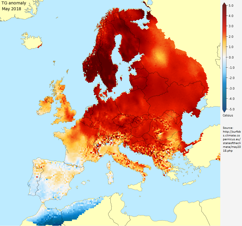 During the day, the same +13 … +14, and at night about +3 degrees. During the month, only two millimeters more precipitation falls. Humidity is also almost the same, despite the proximity of the coast.
Also similar weather conditions are observed in the middle of spring in Munich – the capital of Bavaria, which is the southernmost province of the country. During the day, the air warms up to +13…+15 degrees, at night it still gets significantly colder to +3…+4, but without the likelihood of frost. The amount of precipitation is not much higher than that observed in other regions of the state – about 50 mm during the month. Humidity is at 70%. In general, the weather in April in this region is already quite comfortable for travel.
Somewhat warmer in the west of the country, in Cologne and Düsseldorf. Here during the day the temperature rises to +15 degrees, and at night it does not fall below +5 degrees. Humidity is 70%, but despite this, the amount of precipitation is noticeably higher than in March and is 60 mm. The western regions of Germany are adjacent to the Netherlands, so the weather here is similar. In April, tulips are still actively blooming, visiting parks or squares, you will be convinced that the pictures that you have seen on the Internet can only remotely convey the natural beauty of blooming April.
At ski resorts, April is the end of the season, which will open again not earlier than October-November, and then in a favorable cold and snowy year. But at the very beginning of the month, under favorable circumstances, you can still go skiing or snowboarding from the mountains.
Going to Germany, you can count on the weather in April to be favorable to you and the trip from this point of view will be very pleasant. Comfortable shoes, fairly light clothes and an umbrella – that’s all you need for comfort in the middle of spring in any region of the most developed country in the European Union. Visiting the country during this period is still good because the tourist flows are still moderate, as well as prices, which is important. At the same time, according to the calendar, Christian holidays often fall precisely in April, and if you come here at this time, you can become a participant in many holidays and festivals that the Germans love to celebrate. Have a nice holiday.
Where is the best place to relax in Germany in April?
This table will help you determine which German resorts are warmest in April, find out where there is less rain and more clear days.
Do you want to know where is the warmest sea? We also provide information about the water temperature in seaside resorts.
| Resort name | Air temperature day / night |
Cloudy | Rainy days / rainfall |
Sea water temperature | Solar clock * |
|
|---|---|---|---|---|---|---|
| Aachen | 12.6°C | 5.5°C | 47.0% |
2 days (36.4 mm.) |
– | 08h. 20m. |
| Augsburg | 13.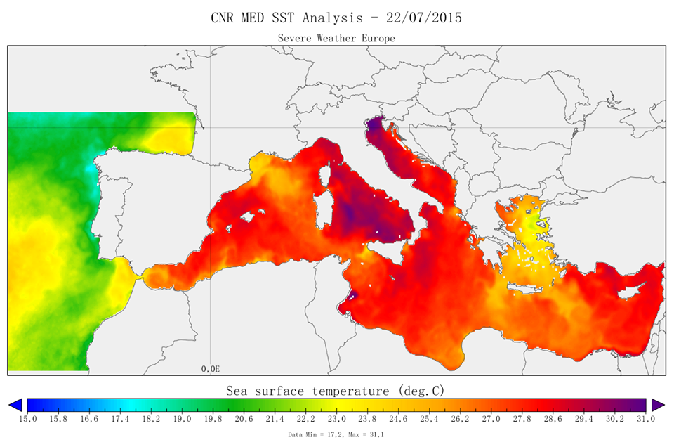 2°C 2°C |
4.5°C | 45.6% |
4 days (46.5 mm.) |
– | 08h. 27m. |
| Bavaria | 13.0°C | 5.1°C | 46.0% |
4 days (47.4 mm.) |
– | 08h. 25m. |
| Bad Reichenhall | 13.0°C | 2.4°C | 46.7% |
7 days (91.7 mm.) |
– | 08h. 16m. |
| Baden Baden | 14.3°C | 5.7°C | 44.4% |
3 days (53.5 mm.) |
– | 08h. 37m. |
| Berlin | 14.0°C | 6.8°C | 48.3% |
2 days (28.2 mm.) |
– | 08h. 12m. |
| Berchtesgaden | 13.1°C | 2.3°C | 47.2% |
7 days (89.8 mm.) |
– | 08h. 12m. |
| Bonn | 14.4°C | 6.2°C | 44.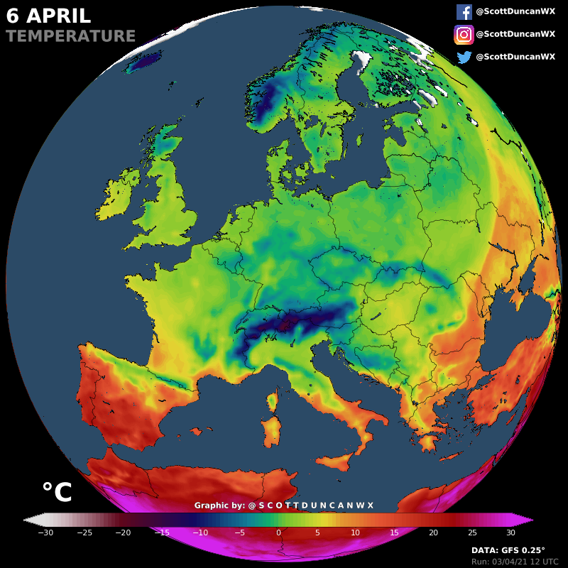 5% 5% |
2 days (36.5 mm.) |
– | 08h. 41m. |
| Bochum | 13.8°C | 7.1°C | 47.5% |
2 days (35.3 mm.) |
– | 08h. 17m. |
| Bremen | 12.7°C | 5.3°C | 47.8% |
3 days (40.0 mm.) |
8.7°C | 08h. 18m. |
| Wiesbaden | 14.7°C | 7.3°C | 42.1% |
2 days (31.8 mm.) |
– | 08h. 59m. |
| Würzburg | 13.5°C | 5.5°C | 44.5% |
2 days (37.7 mm.) |
– | 08h. 39m. |
| Hamburg | 12.3°C | 5.3°C | 48.1% |
2 days (36.6 mm.) |
8.3°C | 08h. 17m. |
| Hanover | 13.2°C | 5.6°C | 48.1% |
3 days (39.7 mm. |
– | 08h. 14m. |
| Garmisch-Partenkirchen | 11.6°C | 0.1°C | 49.3% |
7 days (101.3 mm.) |
– | 07h. 55m. |
| Heidelberg | 14.6°C | 6.5°C | 43.0% |
2 days (34.8 mm.) |
– | 08h. 50m. |
| Dortmund | 13.8°C | 6.8°C | 47.7% |
3 days (39.7 mm.) |
– | 08h. 16m. |
| Dresden | 12.6°C | 5.5°C | 48.7% |
3 days (42.2 mm.) |
– | 08h. 07m. |
| Dusseldorf | 14.3°C | 7.6°C | 45.1% |
2 days (30.1 mm.) |
– | 08h. 37m. |
| Karlsruhe | 15.4°C | 7.1°C | 41.7% |
1 day (27.9 mm.) |
– | 09h. 00m. 00m. |
| Kassel | 13.0°C | 4.5°C | 48.0% |
2 days (36.8 mm.) |
– | 08h. 12m. |
| Koln | 14.7°C | 7.2°C | 43.5% |
2 days (33.0 mm.) |
– | 08h. 50m. |
| Keel | 10.8°C | 4.8°C | 47.2% |
1 day (31.1 mm.) |
6.5°C | 08h. 26m. |
| Leipzig | 13.5°C | 5.6°C | 46.6% |
2 days (30.4 mm.) |
– | 08h. 25m. |
| Lübeck | 11.6°C | 4.8°C | 46.6% |
1 day (31.8 mm.) |
6.1°C | 08h. 30m. |
| Magdeburg | 13.6°C | 6.0°C | 45.2% |
2 days (32.2 mm.) |
– | 08h. 37m. |
| Mainz | 14. 8°C 8°C |
7.2°C | 42.8% |
2 days (27.5 mm.) |
– | 08h. 53m. |
| Mannheim | 15.2°C | 7.5°C | 41.8% |
1 day (30.1 mm.) |
– | 09h. 01m. |
| Munich | 13.4°C | 4.8°C | 46.7% |
5 days (61.4 mm.) |
– | 08h. 17m. |
| Nuremberg | 13.9°C | 5.4°C | 44.3% |
2 days (36.6 mm.) |
– | 08h. 40m. |
| Regensburg | 14.2°C | 5.5°C | 43.1% |
2 days (38.4 mm.) |
– | 08h. 49m. |
| Rostock | 10.8°C | 5.4°C | 44.2% |
2 days (36.3 mm.) |
7.5°C | 08h. 51m. |
| Rust | 15.1°C | 6.0°C | 40. 3% 3% |
2 days (40.4 mm.) |
– | 09h. 10m. |
| Saarbrücken | 14.1°C | 5.9°C | 45.0% |
3 days (41.6 mm.) |
– | 08h. 33m. |
| Freiburg | 14.2°C | 4.9°C | 41.3% |
3 days (48.0 mm.) |
– | 09h. 01m. |
| Frankfurt am Main | 14.8°C | 7.0°C | 41.2% |
2 days (31.5 mm.) |
– | 09h. 07m. |
| Füssen | 10.2°C | 0.3°C | 50.3% |
9 days (117.2 mm.) |
– | 07h. 47m. |
| Herscheid | 12.0°C | 5.4°C | 50.4% |
4 days (51.0 mm.) |
– | 07h. 53m. |
| Stuttgart | 13.9°C | 5.9°C | 43.2% |
3 days (41. |
– | 08h. 48m. |
| Essen | 14.0°C | 7.3°C | 46.9% |
1 day (26.4 mm.) |
– | 08h. 22m. |
 )
) 0 mm.)
* Sundial – an indicator that displays the average number of hours per day during which direct sunlight reaches the earth’s surface. This indicator is influenced by both the length of daylight hours and cloud cover in the daytime.
Tourist reviews of the weather in Germany in April
Finally, I visited Germany, I dreamed of it for a long time! Of course, I wanted to go at the end of summer or autumn, but it turned out that we went in April. In the spring there, too, it is very good. We were in the middle of the month, the temperature was +9 and rose to +14, it was sunny. There was no rain at all, not even clouds. Flowers are already blooming in gardens and parks, everything is green, the most beautiful are tulips, there are a lot of them. I really liked that it was not hot, so I did not regret that we went in the spring.
See all reviews
Castles of the Rhine. Koblenz, Rüdesheim.
Year after year, millions of visitors come to the romantic Middle Rhine Valley, where between Rüdesheim and Koblenz, there is the largest number of medieval castles in the world.
Castles of the Rhine + Fireworks!
Year after year, millions of visitors come to the romantic Middle Rhine Valley, where between Rüdesheim and Koblenz, there is the largest number of medieval castles in the world.
Two rivers: Moselle and Rhine.
Cochem, Reichsburg Castle and the famous German Corner.
Castles of the Moselle
Eltz, Cochem, Beilstein.
Not Found (#404)
Not Found (#404)
Whoops…something went wrong!
Sorry, we couldn’t find the page you were looking for
Tours
Hotels
Railway tickets
Route
Countries and cities
Location
Cities
Yachting
Expeditions
Dog sled tours
Snowmobile tours
Quad tours
Walking tours
Alloys
Bike tours
Climbing
Ski tours
Diving and snorkeling
Jeep tours
Surfing and SUP tours
Combined tours
Horse tours
Cruises
Excursion tours
Ski trips
Helicopter tours
Fishing tours
Fitness and yoga tours
Canyoning
Railway tours
Are you looking for one of the sections below?
Tours
Hotels
Railway Tickets
Routes
Attractions
We have made a selection of interesting articles for you!
Leave a review
12345
Thank you very much 🙂
Your feedback is very important to us and will be posted on the service as soon as possible.
time!
Weather in Germany in April 2022-2021 at “365 Celsius”
What is the weather in Germany in the month of April is highly dependent on the region. The air warms up at night to +6.5°C, and during the day up to +17.3°C, it rains for 12 days and 18.6 mm of precipitation falls per month. And, for example, in Ribnitz-Damgarten, the weather conditions are not very good, since the air is up to + 8.9 ° C, cloudy and rainy days are at least 11. The best cities to relax at this time are Bonn, Bremen, Nuremberg. The air temperature in April is +14.4°C.
Climate
| Average temperature during the day: | +14.4°C | |
| Number of sunny days: | 13 days | |
| Rainy days: Rainfall: |
12 days 18. |
Is it worth it to come to rest in Germany in April?
The weather in Germany in April is great for holidays, this month’s rating is 4.5 out of five. The weather is not very good, there are few tourists. It rains a lot, about 12 days a month, with 18.6 mm of precipitation. Sunny skies for at least 13 days. The weather in Germany at the end of April at the beginning and middle of the month is presented on the graph. The air temperature in April is +14.4°C. At this time, the best climatic conditions in 3 cities:
| Weather in April Frankfurt am Main | April weather Karlsruhe | Weather in April Taunusstein | |||
|
4 |
air: +16.6°C rain: 3 days sun: 14 days |
4 |
air: +17.3°C rain: 1 day sun: 15 days |
4 |
air: +15. rain: 12 days sun: 16 days |
Best climate in cities in April
| City | Air temperature | Water temperature | Rainy days (precipitation) | |
| Nuremberg | +15.5°C | – | 3 days (33.8mm) | |
| Landau | +15.8°C | – | 12 days (14.45mm) | |
| Cologne | +16.2°C | – | 3 days (25.8mm) | |
| Seligenstadt | +15.8°C | – | 10 days (14. |
|
| Worms | +15.9°C | – | 10 days (11.03mm) | |
| Freiburg | +15.5°C | – | 6 days (46.3mm) | |
| Rodgau | +15.8°C | – | 10 days (14.97mm) |
Full list of cities
Quick city search
Air temperature in Germany in April
The difference in daily air temperature throughout the year is 20.7°C, but due to the presence of the sea, the climate in Germany is quite mild for months. The coldest month is January when the air warms up to +2.7°C, and the warmest month is July with +23. 4°C. The air temperature in April is +14.4°C.
Water temperature in Germany
The beach season here lasts: . The temperature in the sea at this time of the year is from – to – conducive to a pleasant swim. Worst weather in Germany and water temperature recorded in November -. The air temperature in April is +14.4°C.
Number of rainy days and precipitation in April
Unlucky month for travel – July, it rains on average 16 days. The maximum monthly rainfall is 44.3 mm. The air temperature in April is +14.4°C.
Rating of comfortable rest in April
The rating is calculated by months, taking into account the average air temperature, the amount of rain and other indicators. Over the course of a year in Germany, the score ranges from 4.2 in December to 5.0 in August, out of a possible five. The air temperature in April is +14.4°C.
| Month | Air temperature during the day | Water temperature | Solar days |
Rainy days (precipitation) |
| December | +4.2°C | – | 6.5 | 13 days (42.7 mm) |
| January | +2.7°C | +0.0°C | 5.3 | 11 days (37.9 mm) |
| February | +4.0°C | +0.0°C | 8.9 | 9 days (22.9 mm) |
| March | +8. |
– | 9.2 | 11 days (22.1 mm) |
| April | +14.4°C | – | 12.9 | 12 days (19.9 mm) |
| May | +17.8°C | – | 15.8 | 15 days (38.1 mm) |
| June | +20.9°C | – | 14.9 | 15 days (39.2 mm) |
| July | +23.4°C | – | 16.4 | 16 days (44.3 mm) |
| August | +23.1°C | – | 20.1 | 14 days (35. |
| September | +19.0°C | – | 16.6 | 11 days (25.2 mm) |
| October | +13.5°C | – | 9.5 | 11 days (26.3 mm) |
| November | +8.3°C | – | 7.8 | 11 days (27.2 mm) |
Number of sunny days in April
Beautiful sunny weather will delight tourists in August – as many as 21 sunny days per month. Great time to relax in Germany. The air temperature in April is +14.4°C.
- Please note:
- Weather in Germany in March: rating 4.2 (out of 5), air +8.
9°C , rain 11 days
- Weather in Germany in May: rating 4.7 (out of 5), air +17.8°C , rain 15 days
Malta, Budapest, Prague, Vienna, Madeira, Amsterdam
April holidays are great! You can change the situation and relax your body and soul in April in Europe – there at this time of the year it is warm, sunny and the aromas of ripe fruits are in the air.
Weather
The weather in Malta, though not hot in April, is warm enough for Russian tourists who miss summer. The air at this time of the year warms up to [info-box type=”bold”] +20 degrees[/info-box] of heat, water – up to [info-box type=”bold”]+16[/info-box]. The weather in Madeira is also quite warm: the average air and water temperature during the day in April reaches [info-box type=”bold”]+17…+ 18 degrees[/info-box] Celsius. The weather in Paris, according to tourists, is conducive to pleasant romantic walks in April. The air warms up to [info-box type=”bold”]+14 degrees[/info-box].
[info-box type=”warning”]Be aware that strong winds and rains are possible in Paris at this time of the year, so you should carefully consider your wardrobe when going on vacation to the French capital.[/info-box]
The weather in Prague in April 2019 is striking in its variety and inconsistency, but the overall feeling is comfortable, as it is quite dry. The air temperature during the day reaches the mark of [info-box type=”bold”]+12 degrees[/info-box] Celsius.
No Schengen visa
For tourists who do not have the possibility of obtaining a Schengen visa, a holiday in Montenegro is perfect in April. The weather is conducive to a cultural holiday, and tourists can enjoy the beauties and sights of Montenegro comfortably and calmly.
Montenegro flourishes at this time of the year: the traveler will remember the rest with unique walking and car tours, museums, monasteries and architectural monuments.
Events of interest
Madeira surprises tourists with both the weather and the sugar cane festival in April. [info-box type=”bold”]The program includes a sugar fair, tours of the production of molasses and cane cutting[/info-box].
[info-box type=”fact”]Madeira will also host the world’s greatest multi-distance cross-country race. Registration for this race takes place from the beginning of the year. Spending a vacation in Europe in April, you should not count on a beach pastime, but there will be a lot of cultural events and excursions. For example, Prague has everything you need to enjoy the beauties of architecture and envelops the tourist with the unique aromas of blooming flowers and trees in April. The snow in Prague melts back in March, and the pavements are dry and comfortable. [info-box type=”bold”]Prague is getting ready for Easter, and all the fairs and decorations of the city are dedicated to this event[/info-box].
Where to go in April and which European country to choose depends on the preferences of the tourist. Each of the countries will allow the traveler to discover all the charms of ancient and modern cities. So, Budapest in April also welcomes its guests with an abundance of architectural sights. Narrow streets immerse tourists in the atmosphere of the Middle Ages. The weather in Madeira in April will give the traveler many hours of pleasure – it is ideal for visiting cultural and historical monuments. Comfortable, warm, there is no sweltering heat inherent in the summer period.
Where to relax in Europe inexpensively and spend holidays in ski resorts? You can catch the closing of many tourist bases in the Alps.
And in some northern European countries the ski season lasts until the end of spring.
Czech Republic
April in the Czech Republic, according to tourists, is the most favorable time to explore local attractions. The weather is mild, warm and conducive to long walks in Prague and other cities.
Bright colors fill the Czech Republic – blooming tulips, fragrant magnolias and other plants, no less exotic for a Russian, fill the April air in the Czech Republic with delicious smells. Czech walks are relatively inexpensive and comfortable, since the tourist season is not yet open and there are not many people on the streets of Prague, according to tourists.
The Netherlands
The Netherlands is a good choice when traveling to Europe. Amsterdam in April, according to tourists, will give a lot of unforgettable and enthusiastic impressions: [info-box type=”bold”]a sea of tulip fields, rose gardens, unique Amsterdam architecture[/info-box] – all this will make your vacation incomparable.
Austria
Vienna in April, according to reviews, meets vacationers with slightly windy, but quite warm weather. Like most European countries, Austria is flourishing and at a crossroads at this time – [info-box type=”bold”]the ski season is coming to an end, and the summer influx of tourists has not yet arrived[/info-box]. Travelers in Vienna in April will be able to enjoy the rich historical heritage of the country in the most comfortable conditions.
[info-box type=”info”]They will be able to visit small cozy cafeterias and sales, as well as enjoy the flowering streets and the incomparable aromas of blossoming flowers.[/info-box] .
Italy and France
Italy and France are beautiful in April – these countries will envelop vacationers with an inexpressible love atmosphere. There is no influx of tourists at this time of the year, and the trip will become intimate and unforgettable.
Interesting
Germany in April 2023 – rest and weather in Germany
April is the month when the cold finally recedes. Nature is reborn and flourishing, and more than ever you want new vivid impressions. Many decide to go to another country, arranging a mini-vacation for themselves. This article will focus on the features of the April holiday in Germany.
Contents
In April, the country is dressed in floral decorations, every day it gets warmer and warmer, but the evenings still do not give an opportunity to forget about warm clothes
When is the best time to visit Germany? | January | February | March | April | May | June | July | August | September | October | November | December
= “d” .$placeID ?>
} else {
?>
= “ddd” .$placeID ?>
}
?>
Weather in Germany in April
In April, climatic spring finally and irrevocably comes to Germany – with lush greenery, an abundance of flowers and dozens of delicate aromas. The point of return to winter cold is finally behind us. The dull time of the transition period is replaced by sunny, friendly days, the amount of rain is gradually waning. The heavenly body rises higher and higher above the horizon, and the days are noticeably lengthening. Instead of heavy, thick March clouds, weather forecasters promise partly cloudy weather. The dim shades of water in the reservoirs begin to reflect the piercing blue of the skies, from which the soul sings and rejoices. Constantly warming sun rays gradually warm the air, creating a pleasant atmosphere for a long stay outside. Weather changes are directly related to tourist baggage: it is significantly reduced. Despite the improvement in weather conditions compared to March, it will not be possible to completely abandon warm clothes, as the nights remain cool. The current wardrobe includes a demi-season jacket or coat, trousers and waterproof comfortable shoes.
Berlin
+13
Baden-Baden
+16
Dusseldorf
+14
Munich
9000 +13
Gamburgg 9000 +13 9000 14
Frankfurt
+15
Cologne
+15
Germany 14 day weather forecast →
If evening “outings” are planned, it will not be superfluous to grab a scarf and a hat, because with the onset of darkness it becomes dank, and the wind often increases. In the capital, the weather portends very good indicators. The maximum indicators often exceed +18°С, but still be guided by daytime +13..+14°С and nighttime +2..+4°С. In Munich, where it is traditionally a few degrees cooler, daily temperature fluctuations can be from +2°С to +17°С. If we talk about average indicators, then during the day they are about +14°С, and in the evening – about +3..+4°С. In both cities, the chance of rain equates to 10-12 wet days per month. In April, snow rapidly disappears from the mountain slopes, the influx of fans of ski holidays stops until the next season. By the end of the month, snow cover remains only at high altitudes, and streams flow with might and main at the lower stations. The western regions are slightly warmer than the eastern ones. In Cologne, Düsseldorf, Hamburg, Frankfurt am Main and Bremen, +15..+17°С is recorded at noon, and +5..+6°С as dusk falls.
What to do in Germany in April?
The weather is conducive to the study of the rich arsenal of historical, cultural, natural wealth of Germany. There are so many attractions in the country that there will be no time to be bored. The absence of queues at ticket offices and crowding in public places will save a lot of precious vacation time, which in the summer is often wasted due to the big hype. The second month of spring is a good period for traveling with children: it is no longer cold, but not yet hot, and most importantly, numerous attractions, playgrounds and entertainment centers are already open at this time of the year. In addition, April is ideal for admiring the natural beauty, thanks to which Germany has a particularly advantageous position among its European neighbors.
Entertainment and excursions
In April, gardens, squares and parks are rapidly acquiring delicate greenery, and the air is saturated with the sweet smell of flowering magnolias, cherries, bird cherry and daffodils. This is a great time for leisurely walks, picnics, playing badminton, reading books and watching scenes of German life. Summer is still far away, but it is not so difficult to speed up its arrival if you go to one of the largest indoor water parks in the world, Tropical Islands, which is 60 km away. south of Berlin. In addition, no trip is unthinkable without shopping. The sales season is long over, but fashion outlets offer discounts all year round. In Berlin, for example, the first thing people go to for shopping is Designer Outlet Berlin and Priva Fashion-Club. If you are in the capital, do not miss the chance to look into the most famous museums in Germany, which are not yet crowded with visitors.
Among them: the Egyptian Museum, Kulturforum, New National Gallery and Museum Island. In Dresden, the Gallery of Old Masters is very interesting. And if you prefer noisy gatherings and glamorous parties to viewing the exhibits, prestigious metropolitan nightclubs and crazy discos are at your service. In addition to Berlin, Munich is also in the center of attention of the daring youth. Its main feature is the famous beer parties. In institutions called “4004” and “WWII” a lot of colorful audience gathers. In bad weather, seek refuge in authentic taverns and cozy bars serving delicious Bavarian sausages and the best beer in the world. Fans of urban landscapes and architectural styles will take plenty of photos and bring home great photos. In April, there are not as many visitors in Germany as in summer, so the process of photographing will take place in an easy and relaxed atmosphere. It should be noted that this month, the doors of many palaces, fortresses and other memorial structures that were closed during the low season swing open. And they offer visits at discounted prices. If the purpose of your visit is relaxation and serene rest, pay attention to the thermal baths and wellness complexes, where there is everything to relieve stress, rejuvenate and improve your health.
What are the prices for holidays in Germany in April?
April is still the off-season, with its characteristic low prices and discounts. Hotels in the middle of spring are not overloaded, and there are a lot of accommodation options. The exception, perhaps, is the Easter week, when in some cities there is an influx of visitors. If your vacation falls on any major holidays, we advise you to take care of booking accommodation in advance. Also consider buying tickets. Major airlines such as Aeroflot, Air Berlin and Lufthansa, around the end of January – in February, can sell seats on board at reduced prices.
Remember that you can buy a tour to Germany cheaper at
Travelata. ru – search for tours through hundreds of tour operators! Use our promo codes
AF2000turcalendar for add. discount of 2000 rubles (tours from 100tr),
AF1500turcalendar 1500 rubles (from 80tr) and
AF1000turcalendar 1000 rub (from 60tr)!
Pick up a tour to Germany for April →
Find flights to Germany →
Prices for hotels in Germany →
How to relax in Germany in April on your own
Already chosen where to go in Germany in April? For a solo trip you need:
- We book a hotel – do not overpay! We check prices at once on all booking sites at HotelLook
- We buy air tickets on AviaSales – we compare the cost of tickets to Germany from all agencies and airlines
- Book excursions on Tripster – choose and book excursions for April
- Rent a car – compare the prices of all car rental companies. Holidays in Germany in April will be more interesting with a car
- We arrange insurance – prices from all insurers at Cherehapa
- Transfer and taxi – proven service KiwiTaxi
In general, April is a great month for traveling in Germany. The weather acquires features of stability and less and less upsets with unpleasant surprises. There are still relatively few tourists, and sights that are not working in winter are progressively resuming their work. Nature is filled with delightful flowering and incomparable fragrance, which makes the environment very attractive. We can say that this month is shown to those who like to relax brightly, but not noisily.
Weather in Berlin in April 2023
Check the weather for April before planning your holiday in Berlin.
Average weather data includes daytime highs and nighttime lows in temperature, rainfall, hours of sunshine, and water temperature data.
9 2022In April 2021 in April 2020 In April 2019 in April 2018 in April 2017 in April 2016 12 ° C 9,000 9,000 9,000 4 ° C 12 ° C 4 ° C 14 ° C 5 ° C 14 ° C 5 ° C 14 ° C 5 ° C 14 ° C 6°C 15°C 7°C 15°C 7°C 15°C 6°C 10 907 14°C 6°C 11 apr. 15°C 5°C 12 apr. 15°C 6°C 13 Apr. 14°C 6°C 14 apr. 13°C 4°C 15 apr. 14°C 5°C 16 apr. 15°C 5°C 17 apr. 15°C 6°C 18 apr. 15°C 6°C 19 apr. 17°C 7°C 20 apr. 17°C 8°C 21 apr. 17°C 8°C 22 apr. 17°C 7°C 23 apr. 18°C 8°C 24 apr. 17°C 8°C 25 apr. 16°C 7°C 26 apr. 16°C 7°C 27 apr. 17°C 7°C 28 apr. 17°C 7°C 29 apr. 18°C 8°C 30 apr. 18°C 8°C
Daily water temperature in April11 Apr. 12 Apr. 13 Apr. 14 Apr. 15 Apr. 16 Apr. 17 Apr. 18 Apr. 19 Apr. 20 Apr. 21 Apr. 22 Apr. 23 Apr. 24 Apr. 25 Apr. 26 Apr. 27 Apr. 28 Apr. 29 Apr. 30 Apr.
Precipitation by dayLight rain – up to 2.5 mm per hour, moderate rain – up to 8 mm per hour, heavy rain – more than 8 mm per hour, heavy rain from 30 mm. 0.5000 MM 0. 0.5000 MM 0.8750 MM 1.2500 MM 0.2500 MM 0.1250 MM 0.1250 MM 0.0000 MM 10 APR. 0.2500 mm 11 apr. 0.3750 mm 12 Apr. 0.6250 mm 13 apr. 1.1250 mm 14 apr. 1.0000 mm 15 apr. 0.8750 mm 16 apr. 0.5000 mm 17 apr. 0.5000 mm 18 apr. 0.5000 mm 19 apr. 0.1250 mm 20 apr. 0.0000 mm 21 Apr. 0.0000 mm 22 apr. 0.2500 mm 23 apr. 0.8750 mm 24 apr. 0.3750 mm 25 apr. 0.6250 mm 26 apr. 1.5000 mm 27 apr. 0.6250 mm 28 apr. 0.0000 mm 29 apr. 1.1250 mm 30 Apr. 1.3750 mm The maximum daytime temperature in Berlin is 18.0000 °C, the minimum nighttime temperature is 3.5556 °C. The amount of precipitation in April is usually not more than 50 mm, and the number of hours of sunshine is not less than 9. Weather in April at other resorts in GermanyBavaria 16°С Baden Baden 17°С Berlin 17 °С Hamburg 15°С Hannover 15 ° C Dresden 15 ° C Dusseldorf 17 ° C CELN 17 ° C Munich 16 ° C Frankfurt – on – Mine 9000 17 ° C Show all resorts Monthly weather in Berlin
Reviews for vacation in AprilAll reviewsAndrii April 29, 2022 Living Hotel Großer Kurfürst By Derag Berlin photo hotel location Location, relatively close to the center, within walking distance of the metro |