
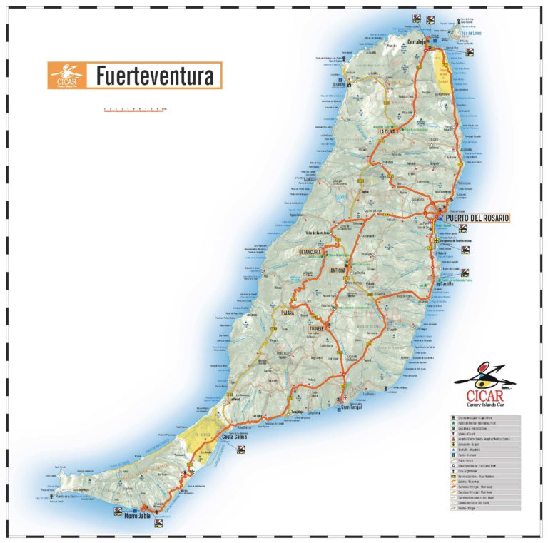
Fuerteventura november temperature: Fuerteventura Weather in November – Will the weather be hot?
Fuerteventura Weather in November – Will the weather be hot?
The kite festival usually takes place on the Corralejo dunes in November
November is pretty much a transition month – the weather is transitioning towards the winter season, which means that the temperatures will drop a bit and the wind will make its presence felt more than in the previous month.
- Weather in Fuerteventura in November
- Can you sunbathe in Fuerteventura in November?
- Average temperatures in Fuerteventura in November
- Rainfall
- Sunshine hours
- Sea temperature in November in Fuerteventura
- Is Fuerteventura hot in November?
- Things to do in November
- Events in November
November is not as busy as the summer months; it’s actually one of the more quiet months in Fuerteventura since most people will wait to visit in December during the winter holidays.
Weather in Fuerteventura in November
Compared to October, the average temperature drops by about 2°C, but during the daytime, you can still expect temperatures of about 23-24°C, which will feel pretty warm when the sun is out.
The wind starts to pick up strength in November, which is why this is the perfect time of the year for the Kite Festival, which takes place on the beautiful Corralejo dunes in the north of the island. If you are in Fuerteventura in November during the time of this festival, we highly recommend you go and see the wonderful kites that the participants bring with them from countries all over the globe (see more details at the end of this article).
Can you sunbathe in Fuerteventura in November?
Although not as hot as during the summer months, November in Fuerteventura will still be considerably warmer compared to most places in Europe like Germany, France, the UK, or any other country in northern Europe.
As long as the sun is out, it will be hot enough to sunbathe even in November, both in the north and south of the island.
It’s true that the chances of rainy days increase as the month progresses to winter, so your impressions and experience will depend on how long you’re staying. If you’re staying for two weeks or more, you have chances to get one or two rainy or overcast days, but you’ll probably be happy if it’s warm and sunny during the remainder of your time on the island. But if you’re coming for a long weekend or a week you might not be as excited about the weather, which could be a bit more unpredictable in November. But all in all, November in Fuerteventura will still we much hotter compared to the rest of Europe, so if you’re looking for a warm destination in November, Fuerteventura is a very good choice.
Average temperatures in Fuerteventura in November
The average high temperature in November in Fuerteventura is around 24°C, while at night you can still expect temperatures of around 19°C. At night you will probably need a jacket to feel comfortable, but during the day beach attire will be sufficient when the sun is out.
- Average high temperature: 24°C (75.2°F)
- Average low temperature: 17.
 7°C (63.9°F)
 - Daily mean temperature: 20.8°C (69.5°F)
 7°C (63.9°F)
In Fuerteventura, the daily mean temperature is 20.8°C (69.5°F) in October, which is calculated as a mean between the average high temperature of 24°C (75.2°F) and the average low of 17.7°C (63.9°F).
Record low & record high temperatures
The highest temperature ever recorded in Fuerteventura in November (at the Airport station) was 34.8°C and the lowest was 10.5°C.
The wind makes all the difference in how the temperature feels. On large and open beaches the wind will create the sensation of a lower temperature than it really is, while on smaller and protected space the wind will not bother you as much.
Rainfall
- Average rainfall (mm): 13 mm
- Average rainy days (>=1mm): 2
Fuerteventura does see a bit more rain in November than October, but the month with the most precipitation remains December.
The average rainfall in November is around 13 mm and this happens over 2 or 3 days, so there’s not much precipitation happening over the course of one day usually.
Sunshine hours
- Monthly sunshine hours in November: 203
- Daily average sunshine hours: 7
- UV Index: 5
Fuerteventura gets an average of 7 hours of sunshine per day in November, while the sun sets at around 18:00 during this month.
Sea temperature in November in Fuerteventura
This is the average sea temperature in November in Corralejo:
- Average sea temperature in November: 21.2°C / 70.2°F
Can you swim in Fuerteventura in November?
With an average of 21.2°C / 70.2°F, the water is still warm enough to swim. Some may prefer a heated pool at this time of year, so it might be useful to ask if the pool at your hotel is heated in November.
Is Fuerteventura hot in November?
What’s the island like and what’s the weather like in Fuerteventura in November?
See what you can expect in terms of temperatures and rainfall in different parts of the island.
| November Weather | Average High °C (°F) |
Average Low °C (°F) |
Rain mm (inches) |
Rain Days |
Average Sun Hours |
|---|---|---|---|---|---|
| Fuerteventura (Airport) | 24 (75.2) | 17.7 (63.9) | 13 (0.51) | 2 | 7 |
| Corralejo | 23.4 (74.1) | 17.3 (63.1) | 11 (0.43) | 3 | 6 |
| Morro Jable (Pajara) | 25.1 (77.2) | 19.2 (66.6) | 4 (0.17) | 1 | 6 |
Things to do in November
Even if the weather is not always suitable for sunbathing, you should see it as an occasion to explore the island and visit some of the wonderful places around. In November the weather is still pleasant enough to allow for long walks and the heat of the sun will not be a problem anymore like it is during the summer.
Playa del Viejo Rey in La Pared
View of Playa del Viejo Rey in La Pared, Fuerteventura
Located on the west coast of Fuerteventura, Playa La Pared provides amazing views and it’s a favorite place for surfers. Even if you’re not into water sports, you can still take in the beautiful views and explore this area of Fuerteventura, which is less known to visitors who usually stay in the more popular resorts like Caleta de Fuste or Corralejo.
The Colonel’s Route in La Oliva
Each Tuesday and Friday you can visit 5 interesting places in La Oliva, where you can find out more about the historical heritage of La Oliva and Fuerteventura. The route will take around 4 hours, so you will still have the afternoon free to enjoy a few hours on the beach if you want.
Events in November
Fuerteventura Kite Festival
7 – 13 November 2022
In 2022 the Kite Festival has changed its location to a more suitable one and everyone is expecting that it will be a great edition!
This event has a history going back more than 30 years and it has grown continuously during this time. Nowadays participants gather from corners all over the world and it is an attraction for everyone visiting Fuerteventura in November. The Corralejo dunes are the perfect place for the event and provide a gorgeous backdrop for pictures.
|
Daily high temperatures decrease by 4°F, from 76°F to 72°F, rarely falling below 69°F or exceeding 81°F. Daily low temperatures decrease by 4°F, from 67°F to 63°F, rarely falling below 59°F or exceeding 70°F. For reference, on August 19, the hottest day of the year, temperatures at Fuerteventura Airport typically range from 71°F to 81°F, while on January 23, the coldest day of the year, they range from 59°F to 68°F. Average High and Low Temperature in November at Fuerteventura AirportNov11223344556677889910101111121213131414151516161717181819192020212122222323242425252626272728282929303055°F55°F60°F60°F65°F65°F70°F70°F75°F75°F80°F80°F85°F85°FOctDecNov 176°FNov 176°F67°F67°FNov 3072°FNov 3072°F63°F63°FNov 1175°FNov 1175°F65°F65°F The daily average high (red line) and low (blue line) temperature, with 25th to 75th and 10th to 90th percentile bands. The figure below shows you a compact characterization of the hourly average temperatures for the quarter of the year centered on November. The horizontal axis is the day, the vertical axis is the hour of the day, and the color is the average temperature for that hour and day.
Average Hourly Temperature in November at Fuerteventura Airport
| ||||||||||||||||||||||||||||||||||||||||||||||||||||||||||||||||||||||||||||||||||||||||||||||||||||||||||||||||||||||||||||||||||||||||||||||||||||||||||||||||||||||||||||||||||||||||||||||||||||||||||||||||||||||||||||||||||||||||||||||||||||||||||||||||||||||||||||||||||||||||||||||||||||||||||||||||||||||||||||||||||||||||||||||||||||||||||||||||||||||||||||||||||||
 The thin dotted lines are the corresponding average perceived temperatures.
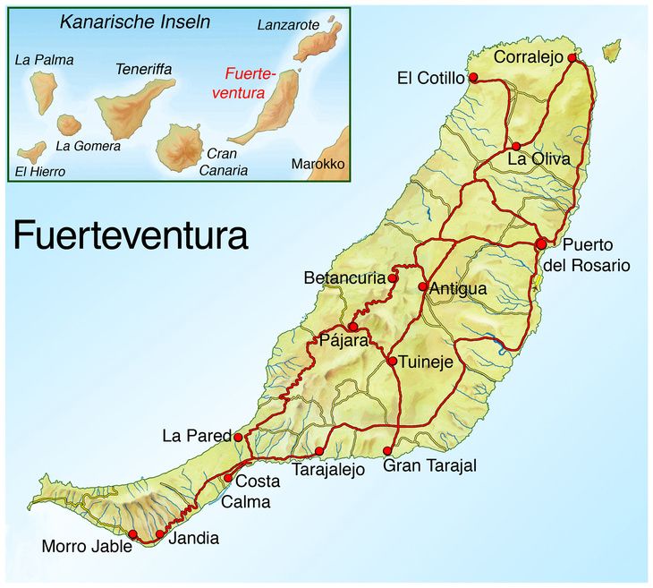 The shaded overlays indicate night and civil twilight.
.gif)

 0 in0.0 in0.5 in0.5 in1.0 in1.0 in1.5 in1.5 inOctDecNov 10.3 inNov 10.3 inNov 300.5 inNov 300.5 inNov 110.4 inNov 110.4 in
 From bottom (most yellow) to top (most gray), the color bands indicate: full daylight, twilight (civil, nautical, and astronomical), and full night.
 The horizontal axis is the day of the year and the vertical axis is the hour of the day. For a given day and hour of that day, the background color indicates the azimuth of the sun at that moment. The black isolines are contours of constant solar elevation.
 The shaded overlays indicate night and civil twilight.
| Nov 2023 | Illumination | Moonrise | Moonset | Moonrise | Meridian Passing | Distance | |||||
|---|---|---|---|---|---|---|---|---|---|---|---|
| 1 | 87% | – | 10:54 AM | WNW | 9:03 PM | ENE | 3:31 AM | S | 239,593 mi | ||
| 2 | 79% | – | 11:51 AM | WNW | 9:59 PM | ENE | 4:27 AM | S | 243,018 mi | ||
| 3 | 70% | – | 12:41 PM | WNW | 10:57 PM | ENE | 5:22 AM | S | 246,095 mi | ||
| 4 | 61% | – | 1:25 PM | WNW | 11:54 PM | ENE | 6:13 AM | S | 248,590 mi | ||
| 5 | 50% | – | 2:02 PM | WNW | – | 7:01 AM | S | 250,338 mi | |||
| 6 | 41% | 12:51 AM | ENE | 2:35 PM | WNW | – | 7:45 AM | S | 251,250 mi | ||
| 7 | 32% | 1:45 AM | ENE | 3:04 PM | WNW | – | 8:27 AM | S | 251,311 mi | ||
| 8 | 23% | 2:39 AM | E | 3:32 PM | W | – | 9:07 AM | S | 250,573 mi | ||
| 9 | 15% | 3:31 AM | E | 3:59 PM | W | – | 9:46 AM | S | 249,146 mi | ||
| 10 | 9% | 4:25 AM | E | 4:26 PM | W | – | 10:26 AM | S | 247,182 mi | ||
| 11 | 4% | 5:19 AM | E | 4:55 PM | WSW | – | 11:07 AM | S | 244,862 mi | ||
| 12 | 1% | 6:17 AM | ESE | 5:27 PM | WSW | – | 11:52 AM | S | 242,374 mi | ||
| 13 | 0% | 7:17 AM | ESE | 6:04 PM | WSW | – | 12:40 PM | S | 239,895 mi | ||
| 14 | 2% | 8:20 AM | ESE | 6:48 PM | WSW | – | 1:34 PM | S | 237,573 mi | ||
| 15 | 6% | 9:25 AM | ESE | 7:39 PM | WSW | – | 2:32 PM | S | 235,513 mi | ||
| 16 | 12% | 10:29 AM | ESE | 8:38 PM | WSW | – | 3:34 PM | S | 233,773 mi | ||
| 17 | 21% | 11:28 AM | ESE | 9:43 PM | WSW | – | 4:36 PM | S | 232,364 mi | ||
| 18 | 31% | 12:20 PM | ESE | 10:51 PM | WSW | – | 5:36 PM | S | 231,273 mi | ||
| 19 | 42% | 1:06 PM | ESE | 11:59 PM | WSW | – | 6:33 PM | S | 230,479 mi | ||
| 20 | 50% | 1:45 PM | ESE | – | – | 7:25 PM | S | 229,978 mi | |||
| 21 | 66% | – | 1:05 AM | WSW | 2:21 PM | E | 8:15 PM | S | 229,795 mi | ||
| 22 | 76% | – | 2:10 AM | W | 2:54 PM | E | 9:02 PM | S | 229,980 mi | ||
| 23 | 86% | – | 3:13 AM | W | 3:26 PM | E | 9:49 PM | S | 230,602 mi | ||
| 24 | 93% | – | 4:17 AM | W | 3:59 PM | ENE | 10:37 PM | S | 231,724 mi | ||
| 25 | 98% | – | 5:21 AM | WNW | 4:35 PM | ENE | 11:27 PM | S | 233,376 mi | ||
| 26 | 99% | – | 6:26 AM | WNW | 5:14 PM | ENE | – | – | |||
| 27 | 100% | – | 7:32 AM | WNW | 5:59 PM | ENE | 12:20 AM | S | 235,535 mi | ||
| 28 | 99% | – | 8:37 AM | WNW | 6:50 PM | ENE | 1:16 AM | S | 238,107 mi | ||
| 29 | 97% | – | 9:37 AM | WNW | 7:45 PM | ENE | 2:13 AM | S | 240,931 mi | ||
| 30 | 92% | – | 10:31 AM | WNW | 8:43 PM | ENE | 3:09 AM | S | 243,791 mi | ||
We base the humidity comfort level on the dew point, as it determines whether perspiration will evaporate from the skin, thereby cooling the body. Lower dew points feel drier and higher dew points feel more humid. Unlike temperature, which typically varies significantly between night and day, dew point tends to change more slowly, so while the temperature may drop at night, a muggy day is typically followed by a muggy night.
The chance that a given day will be muggy at Fuerteventura Airport is very rapidly decreasing during November, falling from 32% to 5% over the course of the month.
For reference, on August 31, the muggiest day of the year, there are muggy conditions 71% of the time, while on January 13, the least muggy day of the year, there are muggy conditions 1% of the time.
Humidity Comfort Levels in November at Fuerteventura Airport
Humidity Comfort Levels in November at Fuerteventura AirportNov1122334455667788991010111112121313141415151616171718181919202021212222232324242525262627272828292930300%0%10%10%20%20%30%30%40%40%50%50%60%60%70%70%80%80%90%90%100%100%OctDecNov 132%Nov 132%Nov 305%Nov 305%Nov 1121%Nov 1121%muggymuggyhumidhumidcomfortablecomfortabledrydryoppressiveoppressive
dry
55°F
comfortable
60°F
humid
65°F
muggy
70°F
oppressive
75°F
miserable
The percentage of time spent at various humidity comfort levels, categorized by dew point.
This section discusses the wide-area hourly average wind vector (speed and direction) at 10 meters above the ground. The wind experienced at any given location is highly dependent on local topography and other factors, and instantaneous wind speed and direction vary more widely than hourly averages.
The average hourly wind speed at Fuerteventura Airport is gradually increasing during November, increasing from 12.2 miles per hour to 13.1 miles per hour over the course of the month.
For reference, on July 17, the windiest day of the year, the daily average wind speed is 17.4 miles per hour, while on October 14, the calmest day of the year, the daily average wind speed is 11.8 miles per hour.
Average Wind Speed in November at Fuerteventura Airport
Average Wind Speed in November at Fuerteventura AirportNov1122334455667788991010111112121313141415151616171718181919202021212222232324242525262627272828292930300 mph0 mph5 mph5 mph20 mph20 mph25 mph25 mph30 mph30 mphOctDecNov 112.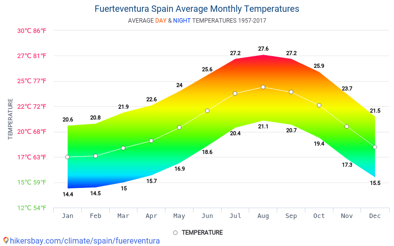 2 mphNov 112.2 mphNov 3013.1 mphNov 3013.1 mphNov 1613.0 mphNov 1613.0 mph
The average of mean hourly wind speeds (dark gray line), with 25th to 75th and 10th to 90th percentile bands.
The hourly average wind direction at Fuerteventura Airport throughout November is predominantly from the north, with a peak proportion of 63% on November 1.
Wind Direction in November at Fuerteventura Airport
Wind Direction in November at Fuerteventura AirportNENov1122334455667788991010111112121313141415151616171718181919202021212222232324242525262627272828292930300%100%20%80%40%60%60%40%80%20%100%0%OctDeceastnorthwestsouth
northeastsouthwest
The percentage of hours in which the mean wind direction is from each of the four cardinal wind directions, excluding hours in which the mean wind speed is less than 1.0 mph. The lightly tinted areas at the boundaries are the percentage of hours spent in the implied intermediate directions (northeast, southeast, southwest, and northwest).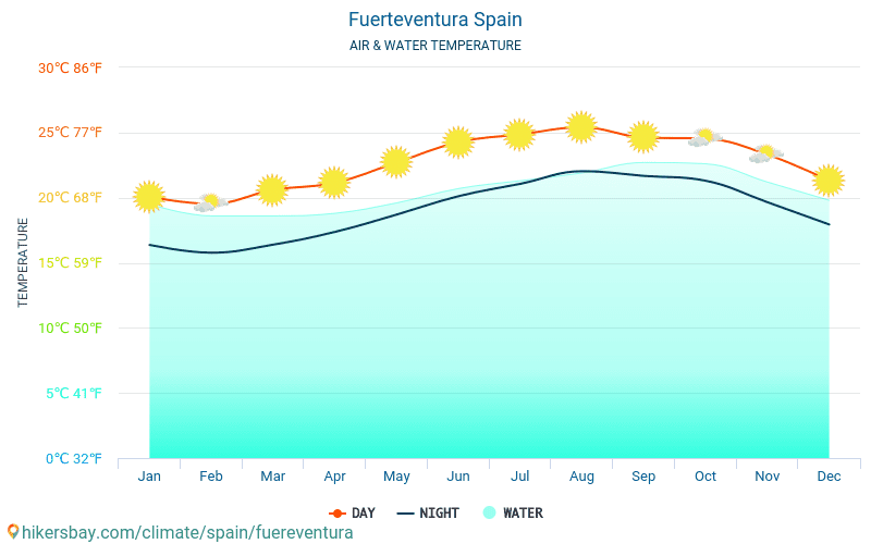
Fuerteventura Airport is located near a large body of water (e.g., ocean, sea, or large lake). This section reports on the wide-area average surface temperature of that water.
The average surface water temperature at Fuerteventura Airport is gradually decreasing during November, falling by 3°F, from 72°F to 69°F, over the course of the month.
Average Water Temperature in November at Fuerteventura Airport
Average Water Temperature in November at Fuerteventura AirportNov11223344556677889910101111121213131414151516161717181819192020212122222323242425252626272728282929303064°F64°F66°F66°F68°F68°F70°F70°F72°F72°F74°F74°F76°F76°FOctDecNov 172°FNov 172°FNov 3069°FNov 3069°FNov 1171°FNov 1171°F
The daily average water temperature (purple line), with 25th to 75th and 10th to 90th percentile bands.
Definitions of the growing season vary throughout the world, but for the purposes of this report, we define it as the longest continuous period of non-freezing temperatures (≥ 32°F) in the year (the calendar year in the Northern Hemisphere, or from July 1 until June 30 in the Southern Hemisphere).
Temperatures at Fuerteventura Airport are sufficiently warm year round that it is not entirely meaningful to discuss the growing season in these terms. We nevertheless include the chart below as an illustration of the distribution of temperatures experienced throughout the year.
Time Spent in Various Temperature Bands and the Growing Season in November at Fuerteventura Airport
Time Spent in Various Temperature Bands and the Growing Season in November at Fuerteventura AirportNov1122334455667788991010111112121313141415151616171718181919202021212222232324242525262627272828292930300%100%10%90%20%80%30%70%40%60%50%50%60%40%70%30%80%20%90%10%100%0%OctDec100%Nov 16100%Nov 16coolcomfortablewarm
frigid
15°F
freezing
32°F
very cold
45°F
cold
55°F
cool
65°F
comfortable
75°F
warm
85°F
hot
95°F
sweltering
The percentage of time spent in various temperature bands.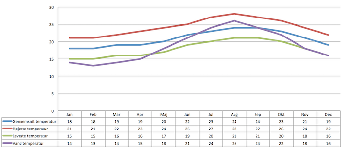 The black line is the percentage chance that a given day is within the growing season.
Growing degree days are a measure of yearly heat accumulation used to predict plant and animal development, and defined as the integral of warmth above a base temperature, discarding any excess above a maximum temperature. In this report, we use a base of 50°F and a cap of 86°F.
The average accumulated growing degree days at Fuerteventura Airport are rapidly increasing during November, increasing by 569°F, from 6,052°F to 6,620°F, over the course of the month.
Growing Degree Days in November at Fuerteventura Airport
Growing Degree Days in November at Fuerteventura AirportNov1122334455667788991010111112121313141415151616171718181919202021212222232324242525262627272828292930305,800°F5,800°F6,000°F6,000°F6,200°F6,200°F6,400°F6,400°F6,600°F6,600°F6,800°F6,800°F7,000°F7,000°FOctDecNov 16,052°FNov 16,052°FNov 306,620°FNov 306,620°FNov 166,361°FNov 166,361°F
The average growing degree days accumulated over the course of November, with 25th to 75th and 10th to 90th percentile bands.
This section discusses the total daily incident shortwave solar energy reaching the surface of the ground over a wide area, taking full account of seasonal variations in the length of the day, the elevation of the Sun above the horizon, and absorption by clouds and other atmospheric constituents. Shortwave radiation includes visible light and ultraviolet radiation.
The average daily incident shortwave solar energy at Fuerteventura Airport is gradually decreasing during November, falling by 0.8 kWh, from 4.4 kWh to 3.6 kWh, over the course of the month.
Average Daily Incident Shortwave Solar Energy in November at Fuerteventura Airport
Average Daily Incident Shortwave Solar Energy in November at Fuerteventura AirportNov1122334455667788991010111112121313141415151616171718181919202021212222232324242525262627272828292930300 kWh0 kWh2 kWh2 kWh3 kWh3 kWh4 kWh4 kWh5 kWh5 kWh5 kWh5 kWh6 kWh6 kWhOctDecNov 14.4 kWhNov 14. 4 kWhNov 303.6 kWhNov 303.6 kWhNov 163.9 kWhNov 163.9 kWh
The average daily shortwave solar energy reaching the ground per square meter (orange line), with 25th to 75th and 10th to 90th percentile bands.
This report illustrates the typical weather at Fuerteventura Airport, based on a statistical analysis of historical hourly weather reports and model reconstructions from January 1, 1980 to December 31, 2016.
Temperature and Dew Point
Fuerteventura Airport has a weather station that reported reliably enough during the analysis period that we have included it in our network. When available, historical temperature and dew point measurements are taken directly from this weather station. These records are obtained from NOAA’s Integrated Surface Hourly data set, falling back on ICAO METAR records as required.
In the case of missing or erroneous measurements from this station, we fall back on records from nearby stations, adjusted according to typical seasonal and diurnal intra-station differences. For a given day of the year and hour of the day, the fallback station is selected to minimize the prediction error over the years for which there are measurements for both stations.
The stations on which we may fall back are Lanzarote Airport and Hassan I Airport.
Other Data
All data relating to the Sun’s position (e.g., sunrise and sunset) are computed using astronomical formulas from the book, Astronomical Algorithms 2nd Edition , by Jean Meeus.
All other weather data, including cloud cover, precipitation, wind speed and direction, and solar flux, come from NASA’s MERRA-2 Modern-Era Retrospective Analysis . This reanalysis combines a variety of wide-area measurements in a state-of-the-art global meteorological model to reconstruct the hourly history of weather throughout the world on a 50-kilometer grid.
Land Use data comes from the Global Land Cover SHARE database , published by the Food and Agriculture Organization of the United Nations.
Elevation data comes from the Shuttle Radar Topography Mission (SRTM) , published by NASA’s Jet Propulsion Laboratory.
Names, locations, and time zones of places and some airports come from the GeoNames Geographical Database .
Time zones for airports and weather stations are provided by AskGeo.com .
Maps are © OpenStreetMap contributors.
Disclaimer
The information on this site is provided as is, without any assurances as to its accuracy or suitability for any purpose. Weather data is prone to errors, outages, and other defects. We assume no responsibility for any decisions made on the basis of the content presented on this site.
We draw particular cautious attention to our reliance on the MERRA-2 model-based reconstructions for a number of important data series. While having the tremendous advantages of temporal and spatial completeness, these reconstructions: (1) are based on computer models that may have model-based errors, (2) are coarsely sampled on a 50 km grid and are therefore unable to reconstruct the local variations of many microclimates, and (3) have particular difficulty with the weather in some coastal areas, especially small islands.